The Santee Sioux Connection to Etowah and Ocmulgee
Were Georgia’s Great Mound Centers Built Around an Ancient Merchant Network?

The Etowah Mounds and Ocmulgee Mounds have long been closely associated with the Muskogean peoples of the Southeast. But what if that is only part of the story? What if another people entirely—one we normally associate with the Santee, a Siouan people from South Carolina but originally of the Upper Mississippi rather than ancient Georgia—were instrumental in the origins of these remarkable places? In this article I will propose that both sites were associated with an ancient Sati/Itsati trading network and explore the archaeological, historical, geographical, and linguistic evidence that supports this new view of two very old sites.
At first the idea sounds improbable. Then you begin looking at what archaeologists actually found.
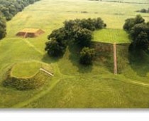
Both Etowah and Ocmulgee were dominated by massive flat-topped earthen pyramids that would have towered over the surrounding landscape. Etowah’s largest mound rises more than sixty feet above the plaza, while Ocmulgee’s Great Temple Mound rises approximately fifty-five feet. These were not small burial mounds hidden among trees. They were monumental artificial mountains, built basket by basket, crowned by large wooden structures, and arranged around broad public plazas where hundreds or even thousands of people could gather. From the summit of the largest mounds, occupants would have looked down over the towns, plazas, rivers, and approaches to the sites.

The similarities go beyond their scale. At both places, monumental platform mounds helped frame a central plaza, creating a dramatic ceremonial landscape in which enormous pyramids rose at roughly right angles to one another. Imagine approaching one of these centers by canoe or trail during the Mississippian period. Above the treeline, the summit structures and perhaps smoke from ceremonial fires would have announced the town long before a traveler entered the plaza. Below, houses clustered around the open space while people gathered for ceremonies, councils, games, markets, and feasts. Whatever else Etowah and Ocmulgee were, they were built to impress.
They were also filled with objects that came from far beyond Georgia.

Etowah yielded spectacular hammered copper plates depicting supernatural human-bird figures, engraved marine-shell gorgets and cups, shell ornaments, ceremonial weaponry, stone statuary, and other prestige objects tied into a vast North American exchange system. Marine shell had traveled inland from the coast. Copper circulated through long-distance networks originating far to the north. Exotic raw materials and finished ceremonial objects passed between communities separated by hundreds of miles. These discoveries have always shown that Etowah was plugged into something much larger than the Etowah River Valley.
Then, in 2026, the story became even stranger.
Researchers identified ancient DNA from cacao in pottery recovered at Etowah. The residues came from feasting contexts associated with the early development of the site and the construction of its first platform mound. Cacao does not grow in north Georgia. It is a tropical plant whose natural range lies far to the south. Somehow cacao, or a prepared product containing cacao, traveled through an exchange system stretching from tropical America all the way to a mound center in northern Georgia.
That discovery changes the scale of the mystery. Long-distance trade was not something Etowah acquired only after it had become a powerful political capital. Exotic products were already arriving while the ceremonial center itself was taking shape. Whatever Etowah was becoming, continental-scale exchange appears to have been part of the story almost from the beginning.
Ocmulgee presents an equally remarkable puzzle. A new population appeared on the Macon Plateau whose pottery and other cultural traits were so different from those of earlier central Georgia populations that archaeologists famously described them as the “Macon Plateau Intruders.” Archaeological terminology has changed, but the basic observation remains: something unusual happened at Ocmulgee, and migration remains a serious explanation for the sudden appearance of this distinctive Mississippian community. Scholars examining the material have repeatedly looked toward northwestern Georgia and eastern Tennessee for some of its closest outside relationships.
The newcomers brought or acquired elaborate marine-shell ornaments, copper objects, distinctive pottery, ceremonial architecture, and other materials demonstrating participation in a much wider world. Archaeologists also recovered prehistoric burials displaying artificial cranial deformation. Whatever cultural significance that practice ultimately had, it adds another unusual element to a site already distinguished by outsiders, foreign connections, monumental construction, and extraordinary ceremonial architecture.
Then there is the location they chose.
Ocmulgee: Where the Canoe Highway Stopped

Ocmulgee sits directly on Georgia’s fall line, the geological boundary where the rolling Piedmont gives way to the flatter Coastal Plain. That may sound like an obscure geographical fact until we imagine the Southeast before railroads, highways, and trucks. Rivers were highways, and large dugout canoes could move considerable quantities of people and merchandise along them. But at the fall line, those river highways encountered shoals, rapids, and abrupt changes in gradient.
For an Indigenous merchant carrying shell, hides, food, stone, copper, pottery, or other merchandise upriver from southeast Georgia, this meant something very practical: the canoe journey was interrupted. Boats might have to stop. Cargo could have to be unloaded and carried around the shoals. Canoes might be dragged or portaged, goods transferred to different boats, or merchandise shifted from river transportation onto inland trails.
That made the Ocmulgee fall line one of the most commercially advantageous positions in Georgia. Anyone established there had access to a natural transfer point between the Coastal Plain and the interior. Traders did not have to dominate every village or river below them. Geography brought the traffic to them. Ocmulgee stood exactly where long-distance commerce was naturally slowed down, reorganized, and redirected.

If a mobile merchant population wanted access to the resources of southeastern Georgia, it is difficult to imagine a better location.
This becomes especially interesting when we remember where archaeologists have looked for the origins of Ocmulgee’s intrusive Mississippian population: northwestern Georgia and eastern Tennessee. Those regions will become important later, because they are precisely where another trail of evidence—the Sati and Itsati place-name evidence—becomes unusually dense.
For now, however, the archaeological mystery is enough. Outsiders appear in central Georgia. They choose one of the most valuable trade choke points in the region. They construct huge monuments, participate in far-reaching exchange networks, practice unusual customs, and create an elaborate ceremonial center that eventually contains one of the strangest symbols in ancient North America.
Two Cities Built to Be Seen
The monumental layouts at Etowah and Ocmulgee deserve more attention than they usually receive in discussions of trade. At both centers, massive platform mounds towered over broad plazas. These structures were ceremonial and political monuments, but their sheer height also made them ideal observation points. A person standing atop a fifty- or sixty-foot mound, especially with a large summit structure rising above it, had a commanding view of the surrounding approaches.

That may have had practical value in a world of long-distance travel.
Spanish eyewitness accounts show that Native communities in Florida and elsewhere used smoke and fire signals to communicate warnings. When Spanish expeditions appeared, signal fires could alert surrounding communities that strangers were approaching. Smoke could be seen over long distances during daylight, while flames would have been visible at night.
This raises an intriguing possibility for the great platform mounds. A signal fire atop one of these enormous artificial hills could have been visible for miles. Such a signal might announce an approaching trading party, summon surrounding communities to a gathering, warn of an enemy force, or communicate information through a chain of settlements. Villages within eyesight of this village but not within eyesight of Ocmulgee could light their own fires and smoke signals to alert villages further afield. In that way, communications could have been nearly instantaneous across vast distances.
We cannot presently demonstrate that Etowah or Ocmulgee operated formal mound-top signaling stations, but the Native signaling system itself is historically documented, and the summit locations would have been extraordinarily well suited to the purpose.
That possibility fits the larger argument developed here. Commerce, ceremony, communications, and political authority did not have to be separate systems. They could all operate from the same monumental center.
And then there is the falcon.
The Mysterious Bird at Etowah and Ocmulgee
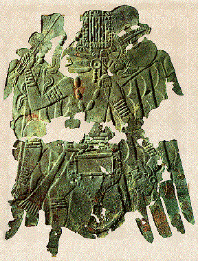
Etowah produced some of the most famous ceremonial artwork in North America. Among the spectacular copper plates recovered from the site are supernatural human figures displaying avian characteristics and the distinctive forked-eye marking associated with the peregrine falcon. The figures combine elements of birds, warriors, ritual authority, weapons, and celestial power. Their appearance is so dramatic that they have become icons of the Mississippian world.
Ocmulgee contains a different but equally striking expression of raptorial imagery. Inside the famous Earthlodge, forty-seven molded clay seats curve around a central hearth. At one end of the chamber is an elevated clay platform sculpted into the shape of a large bird of prey, with additional seats incorporated into the platform. The association between the raptor and positions of authority was literally built into the floor of the ceremonial structure.
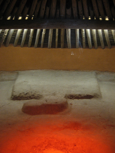
And they both had one other thing in common: a symbol known as the forked-eye motif to archaeologists. The Ocmulgee raptor had the forked-eye motif surrounding its eye. The Etowah Birdman had the forked symbol extending from his mouth onto his face. Thus, at two of Georgia’s most important mound centers, birds of prey with a forked-eye symbol were intimately connected with power and ceremony. At Etowah, the imagery appears on elite copper objects. At Ocmulgee, it becomes part of the architecture itself.
Yet Etowah’s Birdman copper plates did not originate there. They came from further north closer to Siouan territory.
The Birdmen Who Came South
Etowah’s great hammered-copper Birdmen plates are known as the Rogan plates. Their strange winged warriors—with forked markings around their mouth, elaborate headdresses, weapons and trophy heads—have become icons of Mississippian art. Yet there is an important problem with calling them simply “Etowah art.” Archaeologists increasingly recognize that some of the most famous plates were probably not made at Etowah at all.
Their artistic style belongs to what archaeologists call the Braden tradition, centered hundreds of miles northwest of Georgia in the American Bottom around Cahokia. Cahokia was not merely a consumer of copper artwork. Excavations beside Mound 34 uncovered an actual copper-working area dating to approximately AD 1200, where craftspeople hammered and repeatedly heated native copper into the thin sheets needed to manufacture elaborate ceremonial objects. Metallurgical analysis has confirmed the sophistication of that Cahokian industry. (ScienceDirect)
Cahokia’s connection to the Etowah Birdman imagery becomes even more intriguing because growing evidence suggests that the Cahokian world was strongly influenced by populations ancestral to later Dhegiha Siouan-speaking peoples. Osage oral traditions place their ancestors, together with other Dhegiha groups such as the Omaha, Ponca, Kansa and Quapaw, in the Ohio and central Mississippi valleys before their historic dispersal, and Osage cultural historians specifically identify the Cahokia–St. Louis region as an important center of Dhegiha settlement during the Emergent Mississippian period around AD 1000.
The Smithsonian now describes the famous Rogan Birdman plates from Etowah as heirloom copper repoussé plates of Cahokian origin, ultimately deposited with the ceremonial regalia of an Etowah chief. (Smithsonian) That word—heirloom—may be more important than it first appears.
Archaeologist Adam King has argued that Etowah’s remarkable resurgence was connected to what he calls a Cahokian diaspora. As Cahokia’s political world fragmented, prominent families apparently moved outward from the American Bottom. Some traveled south. Rather than arriving empty-handed, they carried with them the ritual objects, symbols and ceremonial knowledge through which elite authority had previously been expressed at Cahokia. At Etowah, King argues, those families and their ancestral regalia became part of the construction of a new political order.
Then the same broad symbolic language appears dramatically at Etowah and Ocmulgee.
On its own, that would be interesting enough. But Native oral tradition preserves an even more provocative clue—because some long-distance traders reportedly marked their own faces around the eyes.
The Traders with Painted Eyes
Anthropologist Lee Bloch documented Native traditions concerning specialized travelers called Esnesv. These figures were remembered not simply as ordinary people carrying a few goods to the next village, but as long-distance traders, diplomats, intermediaries, and culture-bearers moving through a multilingual and multiethnic world. They traveled established routes, crossed political boundaries, carried merchandise and information, and appear to have enjoyed a degree of recognized protection that allowed them to move through places where an ordinary stranger might have been treated very differently.

Their visual symbolism is remarkable. The esnesv carried staffs decorated with feathers from birds including the eagle, red-tailed hawk, owl, and songbird. They also painted straight white lines around their cheeks and eyes. Bloch records that the Indigenous tradition-bearer himself wondered whether these markings might relate to the ancient Mississippian forked-eye motif.
That is an extraordinary convergence. Etowah’s elite copper figures carry falcon eye markings. Ocmulgee’s ceremonial architecture centers a great bird of prey. Picture Cave preserves Siouan-associated falconid eye imagery around AD 1025. Native tradition remembers long-distance merchant-diplomats traveling with bird insignia and painted markings around their eyes.
The surviving term esnesv comes through a Muscogee-speaking tradition, but that does not necessarily tell us where the institution originated. Trade systems, diplomatic offices, religious practices, and routes can pass from one population to another just as place-names can. A later people can inherit an older institution and give it a word in their own language.
More importantly, we do not have to rely solely on oral tradition to establish that this type of long-distance Native merchant actually existed.
The Spanish met them.
De Soto Encounters the Native Merchant Network
When Hernando de Soto’s expedition traveled through the Southeast in the sixteenth century, the Spaniards encountered a Native commercial world that was already operating across multiple political territories. At Pacaha in the Mississippi Valley they encountered eight men who were not natives of the community in which they were staying. Garcilaso described them specifically as strangers and merchants who had traveled through many provinces carrying merchandise.

Among the commodities these men traded was salt. When questioned by De Soto, they possessed detailed knowledge of distant salt sources many leagues away. Their value therefore came not merely from carrying goods but from knowing the geography of the commercial system: where resources originated, which routes connected different provinces, and how merchandise could be moved between communities.
Other De Soto-era accounts similarly describe Native people who had traveled deep into the interior with traders and possessed knowledge of distant centers such as Cofitachequi and the valuable materials available there. The Spanish were not witnessing a series of isolated villages exchanging occasional surplus with their immediate neighbors. They were encountering a layered commercial system in which specialized travelers moved across broad regions.
This is exactly the kind of system the esnesv tradition remembers.
It is also exactly the kind of system required to explain the archaeological evidence at places such as Etowah and Ocmulgee. Copper did not magically appear in Georgia. Marine shell did not transport itself hundreds of miles inland. Cacao did not walk from tropical America to Etowah. Someone knew the routes, maintained the relationships, negotiated passage through foreign territories, and understood where distant products could be obtained and where they were valuable.
The archaeological record shows us the goods.
The Spanish sources show us the merchants.
Etowah Was Built Beside an Even Older Trade Center
Etowah’s commercial geography becomes even more remarkable when we look just a few miles away. Before the great Mississippian center existed, the nearby Leake site was already participating in continental-scale exchange.

Leake flourished primarily during the Woodland period, approximately 300 BC to AD 650. Its known complex covered more than one hundred acres and included mounds, a large circular ditch, ceremonial areas, domestic spaces, and enormous quantities of local and exotic materials. Archaeologists recovered Flint Ridge chert from Ohio, copper, mica, galena, quartz crystal, and other materials demonstrating connections extending far beyond Georgia.
The network reached into the Midwest, the Tennessee Valley, the Lower Mississippi Valley, the Atlantic Coastal Plain, and the Gulf Coast. Petrographic study even identified a direct ceramic connection between Leake and the Mann site in Indiana.
That means the exact stretch of northwest Georgia where Etowah later developed had already functioned as an important gateway between the Southeast and the Midwest many centuries earlier.
Interestingly, this is the same time period some researchers place the great Siouan dispersal– a great migration that explains how we have Siouan people in both the Upper Midwest and the Southeastern U.S. Perhaps the hiatus from when this trade network broke down in 650 AD and then restarted around 1000 AD provided the necessary time for their languages to diverge enough to explain all the differences linguists see today.
Thus when Etowah located just down river from the Leake Site, perhaps it was no accident. Perhaps that location had cultural memory? Therefore Etowah did not arise in an isolated valley that suddenly discovered long-distance commerce during the Mississippian period. It arose almost beside a place where interregional exchange had already been occurring for generations. The route was ancient before Etowah became powerful.
This raises a different way of thinking about why Etowah developed where it did.
Commerce First, Ceremony Second, Political Power Third
Etowah occupies a very different type of strategic location from Ocmulgee. Ocmulgee sits at a choke point where canoe travel is naturally interrupted by the fall line. Etowah lies within a broader crossroads landscape connecting river valleys, mountain passages, and overland routes through northwest Georgia.
Georgia’s own interpretation of Etowah recognizes the importance of trade along the Etowah River, and the central plaza functioned as far more than an empty ceremonial lawn. Large public gatherings took place there, including ceremonies, games, political events, feasting, and exchange.

This suggests a possible sequence in the development of these places. Commercial importance may have come first because the geography made the locations valuable. Ceremony then reinforced that commercial importance by attracting large numbers of people at predictable times. A great festival, burial ceremony, council, game, pilgrimage, or mound-building event could bring visitors from many communities together in one place, and those visitors would not arrive empty-handed. They would bring food, shell, stone, copper, textiles, medicines, tools, weapons, and other goods.
The ceremonial center therefore generated a marketplace, while the marketplace generated wealth. That wealth could support larger monuments, specialists, ritual leaders, and elites. The more impressive the ceremonial center became, the more people it attracted. Political authority could then emerge from control of both the economic and sacred functions of the site.
In this model, Etowah and Ocmulgee did not necessarily become trade centers because they were already powerful capitals. They may have become powerful capitals because they controlled trade.
Modern Atlanta offers a useful analogy. Atlanta did not become a major southeastern city because a unique mineral deposit or agricultural resource existed beneath it. It became important because transportation lines converged there. Connectivity generated commerce; commerce generated population and institutions; and political importance followed. Etowah may reflect an ancient version of the same geographic principle.
And Now the Santee Enter the Story
Only after recognizing the scale of this ancient commercial system does another body of evidence become meaningful.
Earlier LostWorlds research examined a peculiar historical naming problem involving the Santee Indians of South Carolina and the Santee Dakota of the Upper Mississippi. Once the later English spellings are stripped away, the resemblance becomes more intriguing rather than less.
Early Spanish documentation records the South Carolina Santee as Sati. Far to the northwest, early French sources recorded the eastern Dakota later called Santee or Isanti under forms including Issati and Izatys. Additional historical sources preserve related forms associated with the broader Issa/Itsati/Sati naming problem.
Our previous source audits also showed that the conventional etymologies normally used to explain these names as unrelated are much less secure than later summaries often imply. The important point here is not to repeat those linguistic investigations. It is to recognize that the historical forms themselves create an unresolved problem: Issa, Issati, Izatys, Sati, and Santee appear in geographically distant Siouan contexts.
Then the names begin appearing in the Southeast along precisely the kinds of routes a long-distance trading population might have used.
James Mooney recorded Itsa’ti among the Cherokee at Great Chota and in the Nacoochee-Sautee landscape of northeast Georgia. The Cherokee were not Siouan; they spoke an Iroquoian language. That distinction is important because a population does not need to belong to the language family that originally coined a place-name. Florida is a Spanish place-name, but modern Floridians are not therefore Spanish.
Nearby in the southern Appalachian corridor appear Satico, Settiquo, Citico, and the sixteenth-century town Satapo. These names cluster in eastern Tennessee and the surrounding mountain corridors.
And that brings us directly back to Ocmulgee.
The Ocmulgee Outsiders Came from the Sati Corridor
Archaeologists examining the distinctive Macon Plateau population have repeatedly identified northwestern Georgia and eastern Tennessee as areas containing some of its strongest external relationships.
That is exactly where our Sati/Itsati place-name cluster appears.
This is a much stronger observation than simply noting that two words sound alike. Archaeology independently points toward a migration or cultural connection between Ocmulgee and the same geographic region where the historical Sati-related naming pattern becomes unusually concentrated.

If merchants or colonists associated with that network established themselves at Ocmulgee, their choice of location makes excellent commercial sense. They would have gained access to the fall-line transfer point controlling movement between the interior and southeast Georgia.
Later historical maps add another curious clue: an Echetee town or old-town designation appears in the Ocmulgee corridor.
Echetee is conventionally associated with the Hitchiti. That does not mean the Hitchiti were Siouan, nor does the present hypothesis require them to have been.
Instead, it raises the question of whether the Hitchiti population inherited an older place-name.
The Hitchiti Did Not Have to Be Siouan
Historical traditions portray Hitchiti-speaking peoples as an important older population across a large part of southern Georgia before Muscogee political dominance became widespread. This might initially appear to contradict the idea of a Siouan-associated trade network through the same region.
In fact, it may do exactly the opposite.
Long-distance merchants do not need to replace the populations they trade with. They need those populations to remain productive.
A trader moving shell inland from the Atlantic did not personally spend his days collecting every shell from beaches and estuaries. Coastal communities did that. The merchant did not grow every bushel of maize moving through the exchange network. Farmers did. He did not quarry every stone source, manufacture every local tool, hunt every deer, build every canoe, or produce every craft item entering the system.
Local people produced the merchandise.
The long-distance trader connected those producers to distant consumers.
Without the local population there was nothing worth trading.
This gives us a very different picture of how a Sati merchant network could operate through Georgia. The Sati did not need a giant continuous territory. They could establish communities or enclaves at strategic trade nodes while Hitchiti, Cherokee, Muskogean, and other populations continued occupying the surrounding countryside and producing the goods that made the network valuable.
Their influence might therefore be disproportionately visible in transportation geography rather than territorial archaeology.
Their names might survive at the stops on the route.
Echetee, Satilla, and Ogeechee
That possibility makes several southern Georgia names worth another look.
The Satilla River appears in historical sources under forms including Santilla, Sitilla, and Satilla. This is important because it demonstrates that within this exact southeastern landscape a single geographical name could appear with Santi-, Siti-, and Sati-like forms depending on the recorder and period.
This does not by itself prove that Satilla derives from Sati. It does show that apparently significant differences between Sati, Santi, and Siti cannot automatically be treated as evidence that the names have nothing to do with one another.
Farther north lies the Ogeechee River. Previous LostWorlds research examined the standard etymological explanations for both Georgia’s Ogeechee River and Lake Ogechie in the historic northern Santee region and found those supposedly settled explanations much less secure than later summaries suggest.
Then there is Echetee in the Ocmulgee corridor itself.
Taken independently, each name can be dismissed as an isolated curiosity. Seen in the context of a transportation network, however, they begin to look different. They may represent remnants of places associated with traders moving through territories controlled by other peoples.
That is also why Hitchiti itself deserves future investigation. Hitchiti traditions preserved by early ethnographers indicate that the name was not necessarily the people’s original ancestral self-designation. If the later ethnic name ultimately developed from a town or locality called Echetee, Hitchiti, or a related form, then the modern ethnic label may tell us more about where the people lived than who originally named the place.
Again, none of this makes the Hitchiti Siouan.
It simply allows the place-name to be older than the people who later carried it.
A Small Clue in the Name Etowah
Even the name Etowah offers a minor curiosity. It is traditionally associated with Muskogean italwa, referring to a town or ceremonial community. That explanation may be correct.
There are, however, other possibilities worth remembering. A Siouan people living very near the Santee in South Carolina were historically known as the Etiwa or Etiwaw. Whether there is any historical relationship between Etiwa and Etowah remains to be determined.
For the present argument, nothing depends upon solving that etymology. The stronger point is geographic. Etowah functioned as a crossroads whether or not its ancient name literally described one.
What Would a Merchant Enclave Look Like?
Imagine that all written records of English colonization vanished and archaeologists a thousand years from now tried to reconstruct seventeenth- and eighteenth-century Georgia solely from artifacts and maps.
Suddenly they would encounter foreign materials in Native settlements: glass beads, firearms, European ceramics, metal tools, imported textiles, and other objects from across the Atlantic. Trading establishments would appear at strategically important rivers and trail junctions. At approximately the same time, maps would begin showing unfamiliar English names such as Charleston and Augusta mixed among much older Native geographical names.
Future archaeologists would not conclude that every Native person living around those artifacts had suddenly become English. They would recognize that a relatively small foreign commercial population had inserted itself into an existing Native economic landscape.
Those English merchants would also be completely dependent upon Native producers. European traders did not hunt the enormous quantities of deer whose skins entered Atlantic commerce. Native hunters did. The Europeans connected those hunters to a distant market.
Now apply the same model centuries earlier.

At Ocmulgee, a nonlocal population appears. Its material culture differs substantially from surrounding central Georgia traditions. Its strongest outside connections point toward another region. It occupies the exact geographical point where river commerce is forced to pause. Exotic materials circulate through the settlement. Monumental ceremonial architecture develops. Later maps preserve an unusual Echetee place-name in the same corridor.
That is very close to what a merchant enclave might look like archaeologically.
The Falcon as the Symbol of the Road
This brings us back to the most visually striking piece of the mystery.
Why would long-distance merchant-diplomats be associated with birds of prey and markings around the eyes?
Perhaps because commerce in ancient North America was not merely an economic occupation. A trader moving through multiple territories needed political protection, ritual legitimacy, diplomatic relationships, and a recognizable identity. He needed to be understood as something other than an enemy entering foreign territory.
The Esnesv traditions may provide a glimpse of this system. Their bird-feather insignia and painted eye markings could have communicated a protected social role. Their ability to travel across political boundaries and function among multilingual populations may have depended upon ritual status as much as commercial skill.

If so, the falcon imagery at Etowah and Ocmulgee takes on another possible dimension. The birdman need not have been “just a merchant,” nor should every falcon image be reduced to trade. Rather, the same religious system that empowered warriors, leaders, diplomats, and supernatural intermediaries may also have provided the ideological authority under which long-distance commerce operated.
That would help explain why commerce and ceremony appear so thoroughly intertwined at these centers.
The Mounds as Commercial Beacons
The towering platform mounds may also have reinforced the system visually and practically.
Etowah’s Mound A rises more than sixty feet above the plaza. Ocmulgee’s Great Temple Mound rises roughly fifty-five feet. With summit structures extending still higher, both would have stood above the surrounding treeline and been visible across considerable distances.
Spanish eyewitnesses later documented Native use of fire and smoke signaling in Florida. When strange ships or hostile travelers appeared, communities could alert one another by lighting fires. A similar communications system in Georgia could easily exploit the highest artificial points in the landscape.
A column of smoke from a mound summit could announce the arrival of a trading party during daylight. At night, fire could serve the same purpose. Signals could warn of enemies, summon nearby communities, or communicate the beginning of an important gathering. The same towering monuments used for ceremonies and political display could therefore also function as communication platforms overlooking the trade routes below.
This possibility remains to be demonstrated directly at Etowah or Ocmulgee, but it makes practical sense within a historically documented Native signaling tradition. More importantly, it reminds us that ancient monumental architecture could perform several functions simultaneously. Sacred monument, political theater, lookout, marketplace, and communications platform need not be mutually exclusive categories.
What the New Ocmulgee Dates Really Tell Us
The new chronology at Ocmulgee actually sharpens the geographic connection rather than damaging it.
For decades, the famous Earthlodge was assigned a date around AD 1015. Modern AMS dating has shown that the surviving structure is later, probably dating after the middle of the twelfth century. The old argument that Ocmulgee possessed this fully developed ceremonial complex before Cahokia therefore no longer works.
But another result matters more for this investigation. The revised chronology fits Ocmulgee increasingly well within developments occurring in northwestern Georgia and eastern Tennessee.
Once again, the archaeological connections point toward the very region containing Itsati, Satico, Settiquo, Citico, Satapo, Etowah, and the routes through the southern Appalachians.
Rather than imagining Ocmulgee as an isolated origin point, we can see it as a southern commercial hub connected to a much broader network.
Perhaps the Roads Were Older Than the Cities
The archaeological sequence at Leake suggests that this network may have extraordinarily deep roots.
During the Middle Woodland period, long before Etowah and Ocmulgee reached their Mississippian heights, Leake was already receiving materials from the Midwest and maintaining connections throughout the Southeast. Somewhere in that system were people who understood the routes well enough to move commodities between distant populations.
Centuries later, the Spanish encountered recognizable long-distance merchants doing exactly that kind of work.
Still later, Muscogee oral tradition remembered protected trader-diplomats traveling the Southeast and Midwest with bird insignia and painted eyes.
Perhaps the specific political identities changed while the occupation survived.
Perhaps different peoples took control of the network at different times.
Perhaps the network itself was the durable institution.
Geography would encourage exactly that kind of continuity. Rivers remain rivers. Mountain gaps remain the easiest ways through mountains. Fall lines continue interrupting canoe travel. Portages continue linking watersheds. A political kingdom can disappear in a generation while its transportation system remains useful for another thousand years.
The roads can outlive the people who first built them.
And so can their names.
Were Etowah and Ocmulgee Santee Cities?
Probably not in the simplistic sense of towns occupied exclusively by people whom we could label “Santee Sioux.”
That may be the wrong model entirely.
The evidence explored here points toward multiethnic commercial centers in which local populations, migrant communities, long-distance merchants, ceremonial specialists, political leaders, and travelers interacted. The people supplying shell from the coast did not need to speak the same language as the merchants carrying it inland. The farmer growing maize near Ocmulgee did not need to share the ancestry of the trader eventually exchanging that surplus in another valley.
What mattered was connectivity.
The Sati/Itsati may have been one of the populations specializing in maintaining that connectivity. Their settlements or enclaves could have occupied strategically important points without replacing the surrounding inhabitants. Over time those merchants might disappear, intermarry, migrate elsewhere, or be absorbed into larger political groups while names associated with their commercial nodes remained attached to the landscape.
If that is what happened, archaeologists should not expect to find a uniform “Sati culture” spread across Georgia.
They should expect mixtures.
They should expect local pottery beside nonlocal objects, immigrant populations appearing at strategic nodes, ancient trade centers repeatedly reoccupied, inherited place-names surviving among unrelated peoples, and historical traditions about multilingual travelers who crossed political boundaries.
Remarkably, that is very close to what the evidence actually shows.
The Falcon, the Chocolate, and the Trade Road
The mystery begins with spectacular archaeology. Outsiders appear at Ocmulgee and establish themselves where canoe traffic is naturally forced to stop. Etowah rises beside a river corridor that had already connected Georgia with the Midwest during the Hopewell period. Cacao from tropical America appears in Etowah’s early ceremonial deposits. Copper, marine shell, galena, mica, Flint Ridge chert, and other exotic materials reveal exchange systems reaching hundreds and sometimes thousands of miles.
Both Etowah and Ocmulgee erect enormous earthen pyramids around monumental plazas. Both become commercial, ceremonial, and political centers. Both display powerful raptorial symbolism. Picture Cave preserves Siouan-associated falconid warrior imagery around AD 1025. Native oral tradition remembers long-distance trader-diplomats who carried bird feathers and marked their faces around the eyes. Spanish explorers encountered actual Native merchants traveling through multiple provinces with merchandise and specialized knowledge of distant resources.
Then the place-names appear along the roads connecting these worlds: Sati, Issati, Itsati, Satico, Satapo, Echetee, Sitilla, Santee.
Perhaps they are all coincidences. But there is another possibility.
Perhaps these names do not outline the borders of a forgotten Siouan empire at all. Perhaps they mark places where a mobile merchant population maintained access to the great exchange routes of the Southeast.
The Sati may not have conquered Georgia.
They may have connected it.
If so, that could explain why the evidence appears in fragments rather than as a single archaeological culture. It could explain why their names survive among Cherokee and Hitchiti-speaking populations. It could explain why an intrusive population would choose Ocmulgee’s fall-line choke point, why Etowah would arise beside an ancient Hopewell gateway, and why commerce, ceremony, falcon symbolism, and political authority repeatedly appear together.
The copper had to be carried. The shell had to be carried. The cacao had to be carried. Somebody knew where the salt was. Somebody knew which mountain pass reached the Tennessee Valley and which river carried a canoe toward the Atlantic. Somebody knew the languages and diplomatic customs required to move through foreign territories.
The Spanish met people doing exactly that.
Native oral tradition remembered people doing exactly that.
And perhaps, embedded in the old names scattered along Georgia’s rivers and mountain trails, the landscape still remembers who some of them were.