Tracing the Issa/Itsa Stem
Placenames, Trade Routes, and the Southern Appalachian Copper Belt
Abstract
Across the Carolinas and southern Appalachians, historical records preserve a recurring group of Indigenous names that include forms such as Ysa, Issa, Itsa’ti, and Itse’yi. These names have generally been explained within the languages and communities in which they were recorded. Such local explanations remain important, but geography reveals an additional pattern. The names repeatedly occur at towns, river crossings, mountain passes, and transportation junctions connected by documented Indigenous trade routes.
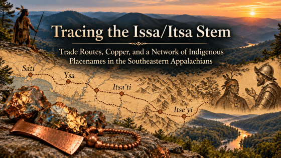
The pattern begins on the South Carolina coast, where early seventeenth-century Spanish accounts recorded Sati, later identified with the Santee, within a riverine exchange system through which people from the interior brought copper and silver to trade for coastal fish and salt. Farther inland, Juan Pardo’s sixteenth-century expeditions recorded Yssa along the Catawba system before reaching Joara at the foot of the Blue Ridge. Cherokee geographic traditions later preserved an east-west route across the mountains as the Suwali-nunna, or “Suwali trail.” Beyond the mountains, James Mooney recorded three separate Cherokee settlements called Itse’yi: one on the Tugaloo system in South Carolina, one on the Little Tennessee near Franklin, North Carolina, and one on upper Brasstown Creek of the Hiwassee in Georgia. He separately recorded Itsa’ti at Great Echota on the Little Tennessee, Little Echota on Sautee Creek, the Nacoochee mound, and other locations.
These sites were not geographically isolated. Historical trading paths joined the Tugaloo to Nacoochee, crossed the Blue Ridge through Unicoi Gap, entered the Hiwassee valley, and continued toward Chota and the Overhill towns. Another branch connected the Tugaloo-Clayton region with the Middle Towns around Franklin and Nikwasi. The resulting transportation network closely overlaps the recurring Itsa/Itse names.
The same landscape also contains significant copper resources. The Ducktown sulfide district extends southwest into Georgia; copper mineralization, including probable chalcopyrite, is documented near Hiawassee itself; copper artifacts were recovered from Nacoochee; and trace-element analysis of a copper celt from Etowah indicated a southern Appalachian rather than Great Lakes source. A Revolutionary War pension statement adds an unexpected historical detail by explicitly naming a “Brass Town on Tugalo River” in 1776, in approximately the same landscape where Mooney later located an Itse’yi settlement that he said whites called Brasstown.
Taken together, the evidence does not prove that every Issa, Itsa, and Itse form originated from a single language or population. It does, however, reveal a coherent naming and exchange landscape. The recurring names follow the routes by which people, minerals, marine resources, and information moved between the Atlantic slope and the southern Appalachian interior. The possibility that an older Issa/Itsa stem survived within this network therefore deserves to be tested against the geography as well as against later language-specific etymologies.
The Problem of the Name
Historical Indigenous placenames rarely survive unchanged. Europeans recorded unfamiliar sounds through Spanish, French, or English spelling conventions; later populations could preserve names inherited from earlier inhabitants; and speakers of a new language could reinterpret an opaque old name through similar-sounding words in their own vocabulary. Consequently, a convincing placename history requires more than identifying a later word that resembles a historical name. The chronology, documentary spellings, geography, linguistic structure, and movement of the people who used the name must all be considered.
The Issa/Itsa problem is particularly useful because several independently documented forms occur across different regions and languages. In the Upper Midwest, early French records preserved names such as Izatys and Issati for the eastern Dakota later known in English as Santee or Isanti. A nineteenth-century Hidatsa dictionary recorded i tsa’ti specifically as the Hidatsa pronunciation of the Isanti or Santee Dakota. The comparison is important because it demonstrates historically, rather than hypothetically, that a name known in English as Santee could be rendered in another Indigenous language by a form extremely close to i-tsa-ti. (DeMallie 2001, 751; Matthews 1877, 161)
This northern evidence does not establish the origin of southeastern Itsa’ti. It provides a comparative control. It shows that Santee, Issati, Isanti, Izatys, and i tsa’ti can belong to the documented history of the same ethnonym despite substantial differences in spelling. That fact makes it reasonable to investigate southeastern Issa/Itsa forms comparatively rather than treating every change from s to ts or ch as evidence that the names must be unrelated.
Cherokee transcription presents a similar difficulty. Mooney specifically observed that the Cherokee consonant written ts was commonly represented as ch by early traders. The historical movement from forms such as Itsa’ti to Echota or Chota is therefore not conjectural sound manipulation; it reflects a documented problem of English orthography. (Mooney 1902)
For clarity, two Cherokee names must nevertheless be kept distinct. Mooney recorded Itsa’ti, whose meaning he said had been lost, and Itse’yi, which he interpreted as “new green place” or “place of fresh green.” They may ultimately prove historically related, or they may not. The geographic argument does not require them to have been identical words. What matters initially is that both sets of names recur within the same transportation landscape and that their historical European spellings frequently occupy the same ts/ch phonetic territory. (Mooney 1902)
Sati on the Atlantic Side of the Network
The earliest firmly documented southeastern evidence begins not in the mountains but on the Atlantic drainage. John R. Swanton’s publication of the reports of Francisco Fernández de Écija records a town called Sati, on the Santee system in the early seventeenth century. Swanton concluded that there was little doubt that this Sati was the people later known to the English as the Santee, explaining the English n as a representation of nasalization that Spanish recorders did not write. (Swanton 1916)
More important for the present investigation is what Écija learned about trade. Indigenous informants described the Santee River as a major avenue into the interior. People from inland traveled down it in canoes bringing goods that included copper and silver, which they exchanged for fish and salt near the coast. They also described a route inland toward a populous mountain region called Xoada, passing through a succession of named towns. Swanton identified Xoada with the Sara/Cheraw country. (Swanton 1916)
This is an unusually important piece of evidence because it establishes the economic geography before any attempt is made to connect the names. In the first decade of the seventeenth century, the Sati/Santee landscape already lay at the eastern end of a documented coast-to-interior exchange system. Copper was not merely present somewhere in the Southeast; Indigenous informants specifically described it being transported from the interior toward the coast.
The Sati name therefore enters the historical record in precisely the type of setting in which a merchant or corridor name could travel: a navigable river, a coastal resource zone, and a chain of inland communities linking the coast to the Piedmont and mountains.
Yssa and the Catawba Route to Joara
A second early form appears farther inland in the records of Juan Pardo. Leaving Santa Elena in December 1566, Pardo followed the Congaree-Wateree-Catawba system northward. His route passed through several Indigenous communities, including Yssa, before reaching Joara near the foot of the Blue Ridge. Modern reconstructions place Yssa within the South Fork Catawba corridor and identify Joara with the archaeological landscape at the Berry site near Morganton, North Carolina, where the Spanish established Fort San Juan. (Moore 2006; Beck, Rodning, and Moore 2016)
Yssa was not an incidental name encountered at the edge of the route. During Pardo’s later expedition, when he stopped again at Joara, Indigenous leaders from surrounding communities came to meet him. The surviving account specifically includes a leader from Ysa Chiquito, “Little Ysa,” among those arriving at Joara. The episode demonstrates direct political movement between a Ysa community and the Joara center. (Beck, Rodning, and Moore 2016)
The significance of Joara is geographic as much as political. It stood near the transition from the Piedmont river systems into the Blue Ridge and Appalachian interior. Pardo’s movements show that communities east of the mountains were connected through it with routes continuing westward. Rather than envisioning Ysa as a name isolated within one river valley, the sixteenth-century documentation places a Ysa population directly within the approach to one of the principal mountain gateways.
This matters because a second body of evidence preserves the memory of an east-west route across the same mountain barrier.
The Suwali Trail Across the Blue Ridge
James Mooney recorded the Cherokee name of the route over Swannanoa Gap as Suwa’li-nunna, the “Suwali trail.” He connected the name with the Ani-Suwali, the Sara or Cheraw people of the eastern Piedmont, and noted that the European form Swannanoa developed from the Cherokee name of the trail. He also observed that seventeenth-century traveler John Lederer called the same crossing “Suala pass.” (Mooney 1902)
The importance of this evidence is easily missed if the name is considered only as an etymology for Swannanoa. The Cherokee themselves remembered a major mountain crossing in relation to a people east of the Blue Ridge. The trail therefore preserves a geographic relationship between the Appalachian towns and a Piedmont population associated historically with the Sara/Cheraw world.
Combined with Pardo’s route through Yssa and Joara, the evidence establishes movement rather than merely proximity. The Catawba-Piedmont communities and the Appalachian interior were connected by recognized corridors crossing the Blue Ridge. Names, people, and goods could move through those corridors.
Once the mountains are crossed, the distribution of Itse’yi becomes particularly striking.
The Three Itse’yi Locations
In his Cherokee glossary, Mooney recorded Itse’yi as a name occurring in several places and preserved by Europeans in forms such as Echia, Echoee, and Etchowee. He proposed a Cherokee derivation from a term for fresh green vegetation plus the locative -yi, yielding “new green place” or “place of fresh green.” That etymology must remain part of any serious discussion of the name. (Mooney 1902)
But Mooney also supplied something even more valuable: the locations of three separate settlements bearing the name.
One Itse’yi stood on Brasstown Creek of the Tugaloo River in Oconee County, South Carolina. A second stood on the Little Tennessee River near present-day Franklin, North Carolina, probably near the mouth of Cartoogaja Creek. A third stood on upper Brasstown Creek of the Hiwassee River in Towns County, Georgia. (Mooney 1902)
These three places form a remarkable geographic triangle. The eastern Itse’yi lies in the Tugaloo-Lower Cherokee country. The northern Itse’yi lies at Franklin within the Middle Towns and the upper Little Tennessee system. The southwestern Itse’yi lies in the Hiwassee-Brasstown landscape immediately east of the Valley Towns.
They are not three randomly scattered points.
They occupy three successive components of the historic trail network through the southern Appalachians.
Tugaloo: The Eastern Gateway
The Tugaloo was one of the principal gateways from the Savannah River system into Cherokee country. Historical research on the Tugaloo crossroads describes a network of Lower Cherokee towns tied together by trails and identifies routes leading west and northwest toward the mountain settlements. Traders moving inland along the Savannah system entered Cherokee country at Tugaloo, while additional paths connected the Tugaloo settlements with Keowee, the Chattahoochee headwaters, Nacoochee, and communities farther west. (Bouwman 1980)
Mooney’s eastern Itse’yi was located on Brasstown Creek of the Tugaloo River. This immediately places the name at the eastern entrance to the same mountain system through which colonial traders, Cherokee travelers, and earlier Indigenous traffic moved. (Mooney 1902)
A Revolutionary War pension declaration provides independent confirmation that the English name Brass Town was attached to this Tugaloo landscape by at least 1776. Thomas Blakely recalled marching first to Seneca Town and then to “Brass Town on Tugalo River,” where his force fought Cherokee and Loyalist opponents. His route then continued through other Cherokee settlements, around Hiwassee, and back toward Seneca. (Blakely 1832)
That statement is important because Mooney later identified an Itse’yi settlement precisely on a Brasstown Creek of the Tugaloo. The two records are separated by more than a century but refer to essentially the same geographic setting. Whatever the ultimate origin of the English translation, “Brass Town” was not merely a twentieth-century tourist reinterpretation of a mountain name. It was already in documentary use during the American Revolution. (Blakely 1832; Mooney 1902)
Franklin, Nikwasi, and the Middle Towns
The second Itse’yi occupied the Little Tennessee near present-day Franklin. Mooney himself described an eighteenth-century military advance reaching Echoee (Itse’yi) only a few miles above Nikwasi, the major Cherokee town at present Franklin. (Mooney 1902)
Franklin was not an isolated mountain settlement. The Little Tennessee valley contained a dense group of Cherokee Middle Towns, including Nikwasi, Cowee, Watauga, Iotla, and others. Historical trail research shows a principal route entering this valley from the Clayton-Rabun Gap direction and continuing along the Little Tennessee. Nikwasi functioned as an important ceremonial and political center within that system. (Tortora 2015)
The geographic importance of the Franklin Itse’yi therefore lies in convergence. From this area, movement could continue north and west along the Little Tennessee, turn southwest toward the Hiwassee Valley, or run southeast through Rabun Gap toward the Tugaloo and Savannah drainages. The name again occurs not at a remote terminus but within a transportation junction.
The Franklin location also provides the bridge between the eastern Tugaloo Itse’yi and the third occurrence in the Brasstown-Hiwassee country.
Brasstown Creek and the Hiwassee
Mooney’s third Itse’yi stood on upper Brasstown Creek of the Hiwassee River in Towns County, Georgia. This is the locality traditionally rendered Brasstown in English. Mooney rejected that rendering as a mistake, arguing that whites had confused Itse’yi with the Cherokee untsaiyi, “brass.” (Mooney 1902)
Linguistically, Mooney’s explanation is straightforward and deserves serious weight. Yet the geography surrounding the name introduces evidence that Mooney did not incorporate into his etymological discussion.
Brasstown Creek enters the Hiwassee system within the Valley Town landscape. Historic paths connected this region eastward toward the Middle and Lower Towns and westward toward the Overhill settlements. The Hiwassee valley was therefore not peripheral to Cherokee transportation. It was one of the principal corridors through which travelers crossed from the Georgia and Carolina mountain valleys into the Tennessee country. (Tortora 2015)
This matters because the Tugaloo Itse’yi and the Hiwassee Itse’yi were not merely two settlements sharing a name. They stood near opposite ends of a documented route across the Blue Ridge.
The Unicoi Corridor
The route connecting these places is unusually well documented. The later Unicoi Turnpike began on the Tugaloo River east of Toccoa, crossed the Nacoochee Valley, passed through Unicoi Gap, continued through the Hiwassee country and Murphy, and ultimately reached the Tennessee settlements. The Georgia Historical Society notes explicitly that before the turnpike opened as a road in 1819, the route was already part of a trading path. (Georgia Historical Society 1956)
A detailed historical study of Traveler’s Rest describes the older road beginning near the highest navigable point on the Tugaloo, passing through the Nacoochee Valley and Unicoi Gap, crossing the Hiwassee in Georgia, and eventually crossing the Little Tennessee at Chota. The same study describes routes from the Tugaloo toward the headwaters of the Chattahoochee and the towns of Soquee, Naguchee, and Echota, followed by a difficult mountain path through Unicoi Gap to the Hiwassee and then the Overhill Cherokee. (Bouwman 1980)
The geographic sequence is therefore extraordinary:
Tugaloo / Itse’yi → Nacoochee / Itsa’ti → Sautee-Echota / Itsa’ti → Unicoi Gap → Hiwassee-Brasstown / Itse’yi → Little Tennessee / Chota-Echota / Itsa’ti.
This sequence does not prove that Itse’yi and Itsa’ti are variants of a single word. It demonstrates something different and historically measurable: the two recurring name forms are concentrated along one of the best-documented Indigenous transportation arteries through the southern Appalachians.
A northern branch strengthens the pattern. From the Clayton area, routes also ran toward the Middle Towns along the upper Little Tennessee, placing the Franklin Itse’yi and Nikwasi within the same broader network. Thus all three Itse’yi locations identified by Mooney can be connected through known trails rather than through hypothetical straight lines drawn on a map. (Tortora 2015)
Itsa’ti, Echota, and the Repeated Name
Mooney recorded Itsa’ti separately from Itse’yi. He stated that its meaning was lost and that English spellings included Echota, Chota, Chote, and related forms. The most important settlement bearing the name was Great Echota on the Little Tennessee in Tennessee, the ancient Cherokee capital and peace town. But it was not the only one. Little Echota stood on Sautee Creek in Georgia; the old Macedonia mission on Soco Creek was also called Itsa’ti by Cherokee speakers; and Mooney stated that the great Nacoochee mound likewise bore the name. (Mooney 1902)
The association with Nacoochee is independently repeated in the 1918 archaeological report by George Heye, Frederick Hodge, and George Pepper, who explicitly cited Mooney for the information that Itsa’ti was applied to the Nacoochee mound as well as to Echota/Sautee and the Little Tennessee locality. (Heye, Hodge, and Pepper 1918)
The repeated use of Itsa’ti is important because the sites again fall along the transportation system rather than outside it. Nacoochee lies directly on the old Tugaloo-Unicoi route. Sautee Creek enters the same upper Chattahoochee landscape. Great Echota or Chota stood on the Little Tennessee near the western destination of the road.
Mooney’s note about Cherokee spelling also explains why the visual similarity can be obscured on English maps. If ts was commonly written ch, then Itsa’ti becomes recognizable behind apparently different forms such as Echota and Chota. The historic map reader who searches only for the letters Itsa will therefore miss much of the geographic distribution. (Mooney 1902)
Copper Enters the Geography
The routes would be historically important even without copper. The mineral evidence, however, supplies a plausible economic dimension to the same landscape.
Copper was already moving through southeastern exchange systems when Europeans began describing them. Écija’s informants on the Santee system specifically reported inland people bringing copper and silver downriver for exchange near the coast. Archaeology demonstrates that copper was also present at the mountain gateway itself. Excavations at Nacoochee recovered copper celts, thin sheet-copper ornaments, copper arm bands, and other copper objects. Some occurred in archaeological contexts well below the intrusive historic material near the mound surface. (Swanton 1916; Heye, Hodge, and Pepper 1918)
The source of every Nacoochee copper object has not been established, and copper circulating through the Southeast could originate in more than one region. Yet the older assumption that southeastern copper necessarily came from the Great Lakes is no longer defensible as a universal explanation. In 1958 Vernon Hurst and Lewis Larson compared trace elements in an Etowah copper celt with samples of native copper from Michigan, New Mexico, North Carolina, and Georgia. Their analysis concluded that the Etowah celt had been manufactured from native copper of local origin. (Hurst and Larson 1958)
The result does not establish that Nacoochee copper came from Ducktown, Brasstown, or Hiwassee. It does establish that southern Appalachian copper sources were known and exploited sufficiently for locally sourced copper to enter the Mississippian artifact record.
That makes the geology of the Hiwassee-Brasstown region directly relevant.
The Southern Appalachian Copper Belt
The best-known copper district of the southern Appalachians is the Ducktown-Copperhill district centered near the Tennessee-Georgia boundary. Geological investigations show that the mineralized district does not stop at the state line. Charlotte Abrams’s study of the southwest Ducktown district identifies abandoned sulfide mines and prospects in Fannin County, Georgia, as the southwestern continuation of the Ducktown system. She describes a northeast-southwest belt extending approximately thirteen miles into the Epworth, Georgia, quadrangle, with copper and zinc among the base metals present. (Abrams 1987)
The principal copper-bearing mineral in such sulfide deposits is chalcopyrite, CuFeS₂, one of the most important copper ores. Mineralogical descriptions characteristically identify fresh chalcopyrite by its brass-yellow color. The distinction is essential: chalcopyrite is not brass, nor does its presence imply Indigenous manufacture of the copper-zinc alloy called brass. It is a naturally occurring copper-iron sulfide whose fresh metallic appearance is visibly brass-yellow. (Kimball 2013)
Copper mineralization also occurs closer to Hiwassee and Brasstown than the major Ducktown mines. The Georgia Geological Survey records copper, probably present as chalcopyrite, at the Berrong or Johnson prospect approximately four miles south-southeast of Hiawassee in Towns County. The same survey records additional copper-bearing mineral occurrences in the county. (Cook 1978)
This changes the geographic question. The third Itse’yi did not merely happen to lie somewhere in the southern Appalachian mountains while major copper deposits existed many valleys away. The Hiwassee landscape itself contains documented copper mineralization, while the much larger Ducktown district lies along the adjoining western transportation system.
A traveler following the old route from Tugaloo through Nacoochee and Unicoi into the Hiwassee country was entering a mineral-rich zone that opened westward toward one of the Southeast’s principal copper districts.
Reconsidering Brasstown
The conventional explanation for the name Brasstown comes from James Mooney’s treatment of the Cherokee placename Itse’yi. Mooney translated Itse’yi as “new green place” or “place of fresh green,” deriving it from a Cherokee word referring to fresh or unripe vegetation together with the locative ending -yi. He then argued that English speakers mistakenly confused Itse’yi with the similar-sounding Cherokee word untsaiyi, meaning “brass.” Under this interpretation, Brasstown is a folk etymology created by an English mistranslation rather than a name with an independent historical meaning. (Mooney 1902)
There are, however, two substantial problems with this explanation.
The first is chronological and geographical. By the time of the Revolutionary War campaign of 1776, Brass Town was already the English name of a Cherokee settlement on the Tugaloo River. Thomas Blakely, recalling his service under Andrew Williamson, stated that his force marched from Seneca Town to “Brass Town on Tugalo River,” where it fought Cherokee and Loyalist opponents. Dempsey Tyner independently remembered being marched “to Brass Town on the Tugaloo River,” which he described as a Cherokee town then in Cherokee possession. The two pension statements were recorded decades later, but both independently preserve Brass Town as the name of an existing place encountered during the 1776 campaign. (Blakely 1832; Tyner 1832)
This is important because the Tugaloo Brass Town was not the later Georgia locality near Brasstown Bald with which the familiar mistranslation story is usually associated. It was a Cherokee settlement on the Tugaloo River, at the eastern side of the southern Appalachian transportation network. Mooney himself identified one of the settlements called Itse’yi as being on Brasstown Creek of the Tugaloo River in Oconee County, South Carolina. Thus one of Mooney’s Itse’yi locations was already remembered in Revolutionary-era geography as Brass Town. (Mooney 1902; Blakely 1832; Tyner 1832)
This considerably complicates the idea that Brasstown originated as a single later accidental translation of the mountain Itse’yi. The English name was associated with another Itse’yi on the Tugaloo at the eastern end of the same mountain transportation system.
The second problem is even more difficult for the mistranslation hypothesis. Mooney did not identify one Itse’yi. He identified three.
One was on Brasstown Creek of the Tugaloo River in South Carolina. A second was on the Little Tennessee River near present-day Franklin, North Carolina, probably near the mouth of Cartoogaja Creek. A third was on upper Brasstown Creek of the Hiwassee River in Towns County, Georgia. Yet only the Tugaloo and Hiwassee locations became associated with the English name Brasstown. The Franklin Itse’yi did not. (Mooney 1902)
That selective distribution is difficult to explain as a simple phonetic mistake. If English speakers routinely heard Itse’yi and mistakenly translated it as untsaiyi, “brass,” there is no obvious reason why the same mistake should have been made at two Itse’yi settlements but not at the third. The conventional explanation accounts for the similarity of two Cherokee words, but it does not explain why the supposed mistranslation was geographically selective.
A different possibility emerges when the names are considered within the transportation and mineral landscape.
Brasstown may not have been intended as a literal translation of Itse’yi at all. It may instead have functioned as an English nickname for particular Itse’yi settlements associated with the movement, exchange, or acquisition of copper.
Modern cities provide an obvious analogy. Detroit is called Motor City not because Detroit means “automobile,” but because automobile production became so strongly associated with the city that the industry supplied it with a second name. Pittsburgh became the Steel City for the same reason. A Native town could likewise acquire a descriptive English nickname based on a commodity strongly associated with it without that nickname being a translation of its Indigenous name.
This possibility is particularly relevant because the two Itse’yi locations called Brasstown occupied strategic positions on the same east-west transportation system. The Tugaloo settlement stood near the eastern gateway into Cherokee country from the Savannah River drainage. The Hiwassee settlement stood near the western side of the mountain crossing, in a region connected directly with the southern Appalachian copper belt. Between them ran the old route through Nacoochee and Unicoi Gap. Copper therefore could have moved through these communities even if it was not mined immediately beside either settlement. (Bouwman 1980; Abrams 1987; Cook 1978)
The word brass also need not imply that Indigenous miners were manufacturing the copper-zinc alloy now technically called brass. The principal copper-bearing mineral in the southern Appalachian sulfide deposits is chalcopyrite, a copper-iron sulfide with the chemical formula CuFeS₂. Fresh chalcopyrite has a conspicuous metallic brass-yellow to golden-yellow appearance. The resemblance is visual, not chemical: chalcopyrite is a copper ore, not brass. (Kimball 2013)
The brass-yellow color results from the way chalcopyrite interacts with visible light. Its electronic structure causes reflectivity to fall toward the blue portion of the visible spectrum while yellow and red wavelengths are reflected more strongly. The reflected light therefore appears yellow-gold or “brassy” to the eye. Spectral measurements published by the U.S. Geological Survey document the characteristic reflectance behavior of chalcopyrite. (Clark et al. 2003)
To an eighteenth-century observer without modern mineralogical terminology, a yellow metallic copper ore could therefore reasonably be described as brass, brassy, or brass-colored. Such a description would refer to the ore’s appearance rather than its chemical composition.
This interpretation also fits the larger geography better than an isolated translation error. The Tugaloo Itse’yi sat at the eastern entrance to the mountain trading system. The Hiwassee Itse’yi occupied the western side of that system near documented copper mineralization and the larger Ducktown-Copperhill district. The Georgia Geological Survey records copper, probably as chalcopyrite, near Hiawassee itself, while geological work traces the larger Ducktown mineralized belt southwestward into Georgia. The Franklin Itse’yi, although an important crossroads, did not occupy the same relationship to this copper-bearing corridor—and it was not called Brasstown. (Abrams 1987; Cook 1978)
The distinction may therefore be meaningful.
Under this hypothesis, Itse’yi was the Indigenous placename, while Brasstown was a commodity-based nickname applied only to those Itse’yi locations particularly associated with the traffic in brass-colored copper ore or copper derived from it. The two names would never have needed to mean the same thing. English speakers could have known a settlement by its Cherokee name while simultaneously calling it “Brass Town” because of what was obtained, exchanged, or transported there.
The conventional folk etymology reverses that relationship by assuming that Brasstown must be an attempted translation of Itse’yi. The documentary distribution suggests another possibility. There were three Itse’yi settlements, but only two became Brasstowns; one of those was already documented as Brass Town on the Tugaloo River in accounts of the 1776 campaign; and both Brasstown locations stood on a transportation system leading through a region rich in brass-yellow copper ore. (Mooney 1902; Blakely 1832; Tyner 1832; Abrams 1987; Cook 1978)
The more coherent historical hypothesis is therefore that Brasstown was not a translation of Itse’yi at all. It was a nickname attached to particular Itse’yi communities because of their association with the movement or exchange of copper from the southern Appalachian copper belt—much as Motor City identifies Detroit by the commodity and industry with which it became associated rather than by the literal meaning of the city’s name.
From Names on a Map to an Exchange Landscape
Viewed individually, each name can be explained locally. Sati can be studied as a South Carolina Siouan ethnonym. Ysa can be studied within the history of the Catawba coalescence. Itse’yi can be analyzed through Cherokee vocabulary for fresh vegetation. Itsa’ti can be treated as an opaque Cherokee placename preserved as Echota and Chota. Brasstown has conventionally been described as an English mistranslation.
Geography does not necessarily invalidate any of those explanations. It reveals something they do not explain individually.
The names repeatedly occupy the routes.
The Sati/Santee system linked the Atlantic coast to an interior exchange network through which copper was carried downstream. Pardo encountered Yssa while following the Catawba corridor toward Joara and the Blue Ridge. Cherokee tradition preserved the Suwali trail across the mountain barrier toward the eastern Piedmont. Mooney’s three Itse’yi settlements stood at Tugaloo, Franklin, and Brasstown-Hiwassee—three major sectors of the historic Cherokee trail system. Itsa’ti occurred at Nacoochee, Sautee-Echota, and Great Echota/Chota, directly along the Tugaloo-Unicoi-Hiwassee-Little Tennessee route. Copper artifacts occur at Nacoochee; a locally sourced copper object is documented at Etowah; copper mineralization occurs near Hiwassee; and the Ducktown sulfide belt extends southwest into Georgia. (Swanton 1916; Mooney 1902; Heye, Hodge, and Pepper 1918; Hurst and Larson 1958; Abrams 1987; Cook 1978)
The resulting pattern is better described as an exchange landscape than as the territory of a single historical tribe. Languages changed along these routes. Towns were abandoned, rebuilt, renamed, and politically reorganized. Cherokee, Catawban, Siouan, Muskogean, European, and other communities participated in the regional economy at different periods. A persistent placename need not prove continuous ethnic occupation.
This distinction is crucial. The hypothesis proposed here is not that one Santee or Issa nation controlled an uninterrupted commercial empire extending from the Atlantic coast to Tennessee. The documentary evidence does not support such a claim. The narrower proposal is that names built around an Issa/Itsa-like sound complex repeatedly survived at strategic points within a long-lived interregional network, and that their distribution is unlikely to be understood fully if each is studied in geographic isolation.
Reconsidering the Issa/Itsa Stem
Once the routes are reconstructed, the linguistic comparison can be approached more cautiously.
The historical record supplies several independent forms. Spanish documentation gives Sati for the South Carolina people later called Santee. Pardo’s records supply Ysa/Yssa in the Carolina Piedmont. Northern French sources preserve Izatys and Issati for Dakota populations later called Santee or Isanti. Hidatsa independently renders the Dakota ethnonym i tsa’ti. Cherokee preserves Itsa’ti, whose meaning Mooney said was lost, and Itse’yi, which he interpreted through Cherokee morphology. (Swanton 1916; Beck, Rodning, and Moore 2016; DeMallie 2001; Matthews 1877; Mooney 1902)
These forms cannot simply be declared identical. They belong to different documentary periods, linguistic communities, and grammatical environments. Yet neither should their similarities be dismissed before their historical distribution is examined. The Dakota-Hidatsa evidence is especially important because it independently demonstrates an actual Santee ? i-tsa-ti correspondence between two Native languages. Mooney’s observation that Cherokee ts was routinely written ch by English speakers supplies another documented transformation within the southern evidence.
A working model therefore becomes possible. Issa/Itsa may represent an old ethnonymic or geographic stem that circulated through exchange networks and was subsequently incorporated into different languages, acquiring local suffixes, pronunciations, and meanings. Some later explanations may preserve the original meaning; others may represent reinterpretations of an inherited name.
This model makes a testable prediction: the names should cluster not randomly but along old corridors of movement, especially at transfer points where different populations interacted.
That is precisely what the geography presently shows.
Conclusion
The evidence assembled in this study reveals a geographic pattern that is difficult to see when the individual placenames are considered separately. Forms belonging to the broader Issa/Itsa complex repeatedly occur along major transportation corridors linking the Atlantic drainage, the Carolina Piedmont, the southern Appalachian valleys, and the Little Tennessee–Hiwassee system. The historical record places Sati on the South Carolina river system through which inland peoples carried copper and other commodities toward the coast. Pardo’s expeditions encountered Yssa along the Catawba approach to Joara and the Blue Ridge. Cherokee tradition preserved the Suwali trail as a recognized passage between the Appalachian interior and peoples east of the mountains. Farther west, James Mooney recorded Itse’yi at three important locations—on the Tugaloo system, near Franklin on the Little Tennessee, and on upper Brasstown Creek of the Hiwassee—while Itsa’ti survived in names associated with Nacoochee, Sautee-Echota, and the Overhill capital of Echota or Chota.
These were not isolated places. Historical trails connected them.
The Tugaloo served as an eastern gateway into the Cherokee interior. From there, routes led through the upper Savannah drainage toward Nacoochee, crossed the Blue Ridge through Unicoi Gap, entered the Hiwassee valley, and continued toward the Little Tennessee and the Overhill towns. Another branch connected the Tugaloo and Rabun Gap region with the Middle Towns around Franklin. When the locations recorded as Itse’yi and Itsa’ti are placed onto this reconstructed transportation system, the recurring names fall repeatedly at important crossings, junctions, gateways, and exchange centers.
The mineral evidence adds another dimension to that geography. Copper was moving through Southeastern exchange networks before sustained European settlement, and early Spanish testimony from the Santee system explicitly describes inland copper being brought toward the coast. Archaeology demonstrates copper use at Nacoochee and locally sourced southern Appalachian copper at Etowah. Geological studies document copper-bearing sulfide deposits across the southern Appalachian mineral belt, including the Ducktown-Copperhill district and copper occurrences near Hiawassee itself.
This mineral landscape also provides a new way to reconsider the two Itse’yi settlements known historically as Brasstown. Mooney explained the English name as a mistranslation produced by confusion between Itse’yi and a Cherokee word for brass. Yet one Itse’yi on the Tugaloo was already being called Brass Town in accounts of the 1776 Cherokee campaign, while Mooney recorded three Itse’yi locations but only two developed the English Brasstown name. The selective appearance of the nickname therefore requires more explanation than simple phonetic confusion.
The trade geography supplies one possibility. The Tugaloo and Hiwassee Brasstowns occupied opposite sectors of a transportation system leading through copper-bearing country, whereas the Franklin Itse’yi did not acquire the same English nickname. Chalcopyrite, one of the principal copper ores of the southern Appalachian sulfide deposits, has a distinctive metallic brass-yellow color. “Brasstown” may therefore have functioned as a commodity-based nickname for particular Itse’yi locations associated with the movement, exchange, or acquisition of this visually brassy copper ore, much as later cities acquired secondary names from the industries or commodities with which they became associated. Under this interpretation, Itse’yi remained the Indigenous placename while Brasstown described an economic association.
The larger significance of the evidence lies in the relationship between names and routes. The similarities among Sati, Ysa, Issa, Itsa’ti, and Itse’yi deserve linguistic investigation, but the geographic pattern exists independently of any final etymological solution. These names repeatedly occur within a connected landscape through which people, minerals, coastal resources, political delegations, and information moved for centuries.
That pattern suggests that the history of the Issa/Itsa stem may be inseparable from the history of long-distance exchange. A name could move with a population, survive at a strategically important town, be adopted by another speech community, acquire a new suffix or pronunciation, or persist after its original meaning had become obscure. Transportation networks provide the mechanism by which such continuity could occur across linguistic and political boundaries.
The resulting picture is therefore not simply a collection of similar placenames. It is a network.
From the Santee drainage to the Catawba Piedmont, across the Blue Ridge, through Tugaloo, Nacoochee, Franklin, Hiwassee, and the Little Tennessee valley, the documentary and geographic evidence traces a series of interconnected places marked by recurring Issa/Itsa-related names. The same routes intersect one of the most important mineral landscapes of the southern Appalachians.
The names follow the routes, and the routes lead through copper country.
References
Abrams, Charlotte E. 1987. “Base Metal Mines and Prospects of the Southwest Ducktown District, Georgia.” Georgia Geologic Survey Information Circular 78. Atlanta: Georgia Department of Natural Resources. https://dlg.usg.edu/record/dlg_ggpd_s-ga-bn200-pg3-bs1-bi5-bno-p-b78.
Beck, Robin A., Christopher B. Rodning, and David G. Moore, eds. 2016. Fort San Juan and the Limits of Empire: Colonialism and Household Practice at the Berry Site. Gainesville: University Press of Florida. https://doi.org/10.5744/florida/9780813061597.001.0001.
Blakely, Thomas. 1832. Revolutionary War Pension Application S21650, Laurens District, South Carolina, October 19. Transcribed by Will Graves, Southern Campaigns American Revolution Pension Statements & Rosters. https://revwarapps.org/s21650.pdf.
Bouwman, Robert Eldridge. 1980. Traveler’s Rest and the Tugaloo Crossroads. Atlanta: Georgia Department of Natural Resources, Parks, Recreation and Historic Sites, Historic Preservation Section. https://dlg.usg.edu/record/dlg_ggpd_s-ga-bn200-pp6-bm1-b1980-bt7.
Clark, Roger N., Gregg A. Swayze, Richard K. Wise, Eric Livo, Todd M. Hoefen, Raymond F. Kokaly, and Steve J. Sutley. 2003. USGS Digital Spectral Library splib05a. U.S. Geological Survey Open-File Report 2003-395. https://doi.org/10.3133/ofr03395.
Cook, Robert B. 1978. Minerals of Georgia: Their Properties and Occurrences. Georgia Geological Survey Bulletin 92. Atlanta: Georgia Department of Natural Resources. https://dlg.usg.edu/record/dlg_ggpd_s-ga-bn200-pg3-bb1-b92.
DeMallie, Raymond J. 2001. “Sioux until 1850.” In Handbook of North American Indians, Vol. 13, Part 2: Plains, edited by Raymond J. DeMallie, 718–760. Washington, DC: Smithsonian Institution.
Georgia Historical Society. 1956. “The Unicoi Turnpike.” Georgia Historical Marker. Re-erected 2022. https://www.georgiahistory.com/ghmi_marker_updated/the-unicoi-turnpike-2/.
Heye, George G., Frederick W. Hodge, and George H. Pepper. 1918. The Nacoochee Mound in Georgia. Contributions from the Museum of the American Indian, Heye Foundation 4 (3). New York: Museum of the American Indian, Heye Foundation. https://dlg.usg.edu/record/dlg_zlgb_gb0135.
Hurst, Vernon J., and Lewis H. Larson Jr. 1958. “On the Source of Copper at the Etowah Site, Georgia.” American Antiquity 24 (2): 177–181. https://doi.org/10.2307/277479.
Kimball, Bryn E. 2013. “Chalcopyrite—Bearer of a Precious, Non-Precious Metal.” Geology Today 29 (1): 30–35. https://doi.org/10.1111/j.1365-2451.2013.00862.x.
Matthews, Washington. 1877. Ethnography and Philology of the Hidatsa Indians. Washington, DC: Government Printing Office. https://tile.loc.gov/storage-services/public/gdcmassbookdig/grammardictionar00matt_0/grammardictionar00matt_0.pdf.
Mooney, James. 1902. “Myths of the Cherokee.” In Nineteenth Annual Report of the Bureau of American Ethnology, 1897–1898, 3–548. Washington, DC: Government Printing Office. https://repository.si.edu/handle/10088/91694.
Moore, David G. 2006. “Pardo Expeditions.” In Encyclopedia of North Carolina, edited by William S. Powell. Chapel Hill: University of North Carolina Press. https://www.ncpedia.org/pardo-expeditions.
Swanton, John R. 1916. “Some Information from Spanish Sources Regarding Siouan Tribes of the East.” Journal of the Washington Academy of Sciences 6 (17): 609–612. https://www.jstor.org/stable/24521245.
Tortora, Daniel J. 2015. Carolina in Crisis: Cherokees, Colonists, and Slaves in the American Southeast, 1756–1763. Chapel Hill: University of North Carolina Press. https://doi.org/10.5149/northcarolina/9781469621227.001.0001.
Tyner, Dempsey. 1832. Revolutionary War Pension Application S1599, Hamilton County, Tennessee, November 27. Transcribed by Will Graves, Southern Campaigns American Revolution Pension Statements & Rosters. https://revwarapps.org/s1599.pdf.