The Santee Merchant Guild: A Shawnee-Style Enclave Model For Siouan Trade Networks in Pre-Contact Georgia
Abstract
Previous cartographic and toponymic research in my paper “Dakota Sioux Once Lived in Georgia,” demonstrates a highly anomalous historic Santee-Siouan presence within the state of Georgia, anchored by unique regional names such as the Ogeechee River, the Satilla (Santila) River, and the Lacoda Trail. Mainstream Southeastern archaeology routinely rejects a long-distance Siouan footprint along the south Atlantic coastal plain due to a lack of dominant, local Piedmont-style ceramic stratigraphy. This paper resolves this analytical impasse by introducing the Shawnee Enclave Paradigm. Shifting the analytical framework from wholesale territorial displacement to a model of highly mobile, specialized merchant enclaves, this study demonstrates how foreign tribal entities could permanently stamp a landscape with lasting toponyms while operating seamlessly within the sovereign boundaries of host Muskogean and Timucuan chiefdoms.
By analyzing the geopolitical layout of Mississippian interstitial buffer zones and tracking the empirical material evidence of a continental import-export economy—specifically the long-distance transport of raw Upper Mississippi Valley galena cubes and Cahokian copper plates in exchange for coastal lightning whelk shells (Busycon sinistrum) and Yaupon holly (Ilex vomitoria)—this paper establishes the exact mechanisms of why and how the Santee Sioux (Sati) operated a sophisticated macro-regional trade network deep within the pre-contact South. Finally, the paper tracks the collapse of this infrastructure during the 17th-century colonial “shatterzone,” detailing the subsequent fracture of the remaining Sati populations into divergent pathways of retreat.
Keywords
Sati / Santee Sioux, Shawnee Enclave Model, Satilla / Santila River, Ogeechee River, Lacoda Trail, Upper Mississippi Valley Galena, Mississippian Interstitial Buffers, Southeastern Shatterzone, Satapo, Citico, Sautee-Nacoochee.
Section 1: Introduction & The Theoretical Shift
In a previous study, “Santee Sioux Once Lived in Georgia,” this author established a series of profound geographic, cartographic, and linguistic anomalies demonstrating a historic Santee-Siouan presence within the state of Georgia. Toponyms such as the Ogeechee River (mirrored uniquely by Lake Ogechie in the Minnesota Dakota heartland), the Satilla River (recorded on historic maps as Santila or Sati-la), and the ancient Lacoda Trail collectively hint at an extensive Siouan footprint far south of mainstream academic expectations.
However, establishing the physical presence of a group immediately invites two critical historical questions: why were they there, and how did they operate?
Standard Southeastern archaeological paradigms routinely struggle to accommodate long-distance tribal overlays. When mainstream institutional history encounters a lack of dominant, regional Siouan utilitarian pottery (such as Piedmont-style quartz-tempered Uwharrie ceramics) along the Georgia coastal plain, it traditionally dismisses trans-regional connections as coincidental homophenes or isolated, down-the-line trade anomalies. This methodological rigidness assumes that for a tribal entity to exist within a space, it must completely conquer, displace, or culturally replace the local population.
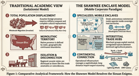
To resolve this impasse, this paper introduces a new operational framework: The Shawnee Enclave Paradigm. By shifting the analytical lens from wholesale territorial migration to a model of specialized, mobile merchant enclaves, we can accurately explain how the Santee Sioux (Sati) left an indelible linguistic and cartographic mark on Georgia’s landscape while seamlessly operating within the sovereign boundaries of host Muskogean and Timucuan nations.
The Shawnee Enclave Paradigm
The historic Shawnee (Shaawanwa) provide an identical, empirically verified blueprint for this type of geopolitical mobility. The Shawnee were not a localized, sedentary bloc; they were an extraordinarily mobile, multi-centered nation that established autonomous trading villages (Chalagawtha) directly inside the territories of other powerful groups. At various points in the late prehistoric and early historic eras, Shawnee enclaves operated simultaneously in the Ohio Valley (their traditional base), the Illinois Country, the Swannanoa Valley of western North Carolina, and along the Savannah and Suwanee rivers deep within the Muscogee (Creek) and Yamasee spheres of influence.
When a Shawnee enclave established a village along a Southern waterway, they did not alter the macro-regional domestic pottery styles of the local Cherokee or Creek populations. They did, however, permanently stamp that geographic feature with their unique ethnonym, giving rise to lasting place-names like the Savannah River and the Suwanee River. They were permitted to occupy these strategic river intersections because they acted as vital, neutral commercial conduits, bringing highly prized northern resources down to Southern chiefdoms.
Redefining the Santee Footprint
Applying this exact framework to pre-contact Georgia completely reframes the archaeological data. This paper argues that the Santee Sioux operated a highly sophisticated, trans-continental “merchant guild” system. The Sati did not arrive in Georgia as an invading army seeking agricultural land; they arrived as corporate and diplomatic trade specialists.
They positioned their enclaves at critical riverine choke points (Satilla, Ogeechee) and along inland thoroughfares (Lacoda Trail) to manage a massive, two-way commercial pipeline connecting the Mississippian midcontinental interior directly to the lucrative resources of the South Atlantic coast. By analyzing the Santee through the Shawnee model, the apparent contradiction between Siouan place-names and Muskogean pottery disappears. The names outlasted the merchants because the enclaves were the very entities controlling the regional import-export warehouses of the ancient South.
Section 2: How They Operated (The Geopolitical Mechanics)
Interstitial Buffer Zones and Lowcountry Topography
To understand how a foreign, northern-rooted merchant network could successfully establish a physical footprint inside the Deep South, one must examine the geopolitical layout of the Mississippian landscape. Pre-contact Georgia was not a continuous, monolithic territory; it was a patchwork of densely populated, highly centralized chiefdoms (such as the Ocmulgee, Etowah, and Coosa provinces) separated by massive, vacant expanses known as interstitial buffer zones.
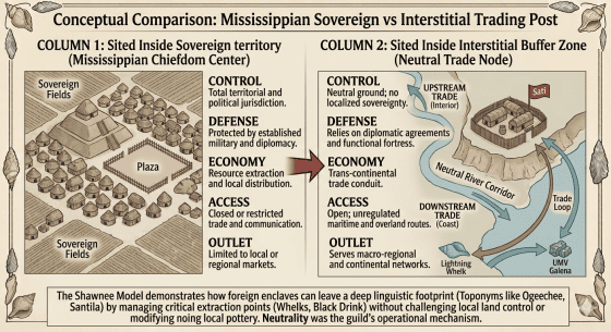
The coastal plain and riverine deltas of southeastern Georgia—characterized by dense pine barrens, tidal marshes, and the blackwater swamps of the Ogeechee, Altamaha, and Satilla rivers—served as a natural geopolitical buffer separating the primary agricultural centers of the Muscogee (Creek) networks to the north and the Timucuan-speaking provinces to the south.
For a specialized merchant enclave like the Sati, these buffer zones represented prime real estate. Because these zones lacked intensive, localized agricultural farming from the dominant chiefdoms, they functioned as open, internationally recognized corporate corridors. By embedding small, well-fortified trading posts within the bluffs of these neutral rivers, the Santee could safely manage a continental supply chain without threatening the sovereign cropfields of local rulers.
The Architecture of the Lacoda Trail
The primary overland artery driving this operation was the Lacoda Trail, an ancient thoroughfare whose footprint was formal enough to be memorialized centuries later by the Georgia General Assembly. Mainstream history frequently views such trails as local hunting paths, but the Lacoda Trail functioned as a highly engineered, trans-continental trade highway.
The trail’s trajectory is highly strategic:
- It originated in the high-country mountains, connecting directly to the Appalachian Piedmont and the Ohio/Mississippi River valleys.
- It cut southward through modern Jackson and Athens-Clarke counties, bypassing major Mississippian military hubs.
- It terminated squarely at the fall line and coastal plains of Georgia, feeding directly into the Ogeechee and Altamaha river networks.
This pathway allowed Santee trade caravans to completely bypass hostile political zones, walking bulk materials straight from the midcontinental interior down to the Atlantic coast. The name Lacoda itself serves as a profound linguistic artifact of this infrastructure, tracking the precise pathway used by northern Siouan (Lakota/Dakota) operators to guide their pack-trains into the Deep South.
The Mountain Gateway: Satapo and the Phonetic Evolution of Citico
To validate the continental reach of the Sati trade network, this operational framework must account for the northern highland corridors that fed raw midwestern resources down into the Lacoda Trail network. This infrastructure is anchored by the historical village of Satapo (frequently recorded by 16th-century Spanish chroniclers as Satipo or Satapo).
During his 1567 expedition into the interior, Spanish explorer Juan Pardo documented Satapo at a critical, highly strategic mountain bottleneck: the confluence of the Little Tennessee River and Citico Creek along the Tennessee-North Carolina-Georgia borderlands. Satapo operated as a classic borderland transit hub—the high-country warehouse where macro-regional merchants could safely gather and sort raw goods before guiding pack-trains south through the Appalachian foothills into Georgia.
The presence of the Sati root at this mountain choke point provides a profound geographical bookend to the coastal Santila/Satilla river basin. Furthermore, it deconstructs a major toponymic mystery by revealing the origin of the regional name “Citico.”
Two of the most prominent Mississippian mound towns in the South Appalachian summit zone bear this name: the Overhill Citico site (Monroe County, TN) and the Citico Mound site (Chattanooga, TN). Anthropologists widely accept that the Cherokee-era Overhill town of Citico sat directly atop the physical footprint of the 16th-century Mississippian village of Satapo.
This direct spatial overlay confirms an intensive sibilant phonetic shift (S-to-C) as the original Siouan ethnonym (Isanti -> Isati -> Satico) was filtered across generations of Muskogean, Cherokee, Spanish, and English trade contact. While the Chattanooga Citico guarded the critical crossing of the Tennessee River Gorge, the Overhill Satapo/Citico operated as the northern processing vault for the Sati trade syndicate.
The Dual-Identity and Diplomatic Neutrality Strategy
Operating a long-distance trade monopoly within foreign territory required immense diplomatic skill. Just like the historic Shawnee, who maintained a complex dual identity as fierce warriors when provoked but indispensable commercial neutrals when trading, the Santee enclaves relied on absolute neutrality.
The Sati positioned themselves as vital, non-partisan economic brokers. Local Muskogean and Timucuan elites were perpetually locked in intense regional rivalries, constantly competing for access to exotic luxury goods that signaled their divine right to rule. By maintaining strict neutrality, the Santee ensured that every local chief had an incentive to protect them. Disrupting or attacking a Santee trading post on the Satilla or Altamaha would mean completely cutting off a chiefdom’s access to sacred Midwestern galena, glossy copper plates, and high-grade stone weaponry.
The Santee did not seek to govern or convert the South; they sought to secure the waterways. By positioning themselves as peaceful, high-value economic allies, they guaranteed their safety and left their tribal names permanently stamped on the landscape long after the networks dissolved.
Section 3: Why They Were Here (The Economic Incentives)
The Midwest Pipeline: Empirical Imports
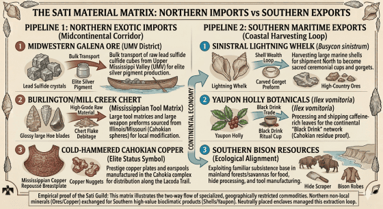
To understand the economic engine of the Sati trading network, one must look at what these northern merchants brought down the Lacoda Trail to buy their security and influence in the Deep South. Prehistoric elites in Georgia required rare, non-local minerals to create the sociopolitical symbols that validated their authority. The Santee enclaves cornered the market on these rare materials by maintaining an exclusive pipeline to the midcontinental interior.
- Upper Mississippi Valley (UMV) Galena: The coastal plain of Georgia is completely devoid of lead ores. Yet, archaeological surveys along the Altamaha River bluffs—most notably those conducted by Clarence B. Moore—have consistently recovered substantial quantities of raw galena (lead sulfide) cubes. Modern lead-isotope sourcing connects these specimens directly to the Upper Mississippi Valley mining district (Wisconsin, Iowa, Illinois) and the Viburnum Trend of Missouri. The fact that these minerals arrive on the Georgia coast as raw, unworked cubes proves they were not passed down through casual, multi-tribal trade chains, but were transported in bulk by a highly organized merchant guild.
- Burlington and Mill Creek Chert: Elite toolkits and weapon caches found at critical riverine intersections in Georgia frequently contain fragments of high-grade midwestern stone. Burlington Chert, native to the Mississippi River bluffs of Illinois and Missouri, was highly prized for its durability and lustrous aesthetic. The presence of Burlington debitage (manufacturing flakes) at these riverine sites indicates that raw stone was being actively processed on-site within these enclaves by resident artisans.
- Cold-Hammered Cahokian Copper: The iconic decorative copper breastplates excavated from burials at elite Georgia sites like Etowah Mounds were proven to have been manufactured in the Cahokia complex. This direct connection tracks the exact physical pathway of the Lacoda Trail as a commercial artery designed to deliver high-status northern metals straight to Southern consumers.
The Coastal Harvesting Loop: Critical Exports
A long-distance trading post cannot survive solely on imports; it requires a highly lucrative local product to justify the immense logistical risk of operating 1,000 miles from home. The Santee established their bases along the Ogeechee, Altamaha, and Satilla rivers specifically because these waterways granted unregulated access to two of the most sought-after luxury commodities in the Mississippian world:
- The Sinistral Whelk Shell (Busycon sinistrum) Trade: The warm, shallow marine waters of the Georgia Bight are the premier habitat for the lightning whelk. To the elites of Cahokia and the wider Midwest, these massive, left-handed spiral shells were the absolute pinnacle of sacred material culture. They were heavily harvested by coastal networks, processed at riverine enclaves, and sent north in massive quantities to be carved into intricate gorgets and used as ritual cups.
- The Black Drink (Yaupon Holly) Monopoly: Ilex vomitoria, the caffeine-rich holly plant used to brew the sacred “Black Drink,” has a highly restricted geographic range limited entirely to the coastal plain of the Southeast. Recent chemical residue and biomarker testing performed on pottery handles at Cahokia has conclusively proven that midwestern populations were consuming the Black Drink on a large scale. The Santee enclaves along the Georgia coast served as the primary supply-chain managers for this intensive botanical export industry.
The Piedmont Foothills Hub: The Sautee-Nacoochee Context
As materials passed south out of the high mountain gaps, they encountered the secondary tier of the pipeline: the Sautee-Nacoochee Mound site situated along the upper headwaters of the Chattahoochee River in White County, northeast Georgia. While local tourism folklore attributes the name “Sautee” to an invented indigenous romance, deep cartographic and administrative records reveal that early European surveyors recorded the small village at the base of the Nacoochee Mound alternatively as the Creek-derived Sawate or explicitly as “Santee.”
The presence of an interior, mountainous Santee village in northeast Georgia matches the linguistic patterns of my proposed coastal Santila/Satilla basin. It confirms that the Sati corporate merchants systematically branded their infrastructure nodes along the entire length of the trans-continental trade highway.
The physical archaeology of the Nacoochee Mound—excavated in 1915 by the Smithsonian Institution and the Heye Foundation—provides concrete, empirical validation for this model. The artifact manifest revealed that Sautee functioned as a booming, long-distance trade hub. Excavators recovered massive volumes of raw, unworked Atlantic marine whelk shells alongside cold-hammered copper ornaments from northern geological zones.
Sautee-Nacoochee did not represent a standard, self-contained farming village; it was a highly strategic, inland Piedmont sorting warehouse. Placed precisely where the mountain passes met the open valleys, this enclave allowed the Sati to manage the upward flow of coastal shell wealth and the downward delivery of midwestern minerals, perfectly executing the corporate goals of the Shawnee Enclave Paradigm.
The Bison Factor: Ecological Alignment
Finally, the physical presence of a Siouan-rooted population in southeastern Georgia is supported by an overlooked ecological reality: the historical range of the American Bison (Bison bison). Historical documentation, such as Francis Moore’s Voyage to Georgia (1736), explicitly confirms that large herds of wild buffalo roamed the mainland forests and savannas right down to the mouth of the Altamaha River, opposite St. Simon’s Island.
To a population with ancestral or cultural roots in the midcontinental plains and river valleys, this localized bison population represented a familiar, vital resource for food, clothing, hide-processing, and tool manufacturing. The Georgia coastal plain was not a completely alien environment to the Sati; it was an ecological mirror of the interior river valleys, offering both immense corporate wealth through trade and a familiar subsistence base through the Southern buffalo herds.
Section 4: The Shatterzone and the Enclave Collapse (The Exit)
The 17th Century Disruption and the Colonial “Shatterzone”
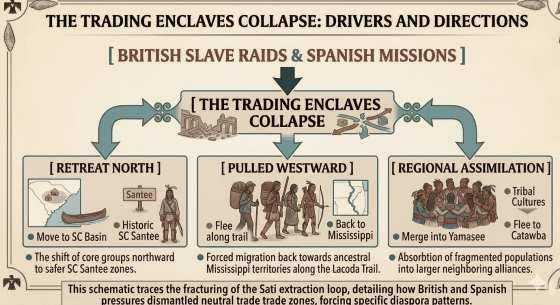
The highly organized, peaceful mercantile network operated by the Sati required a stable, predictable geopolitical landscape to survive. This ancient equilibrium was shattered in the late 16th and 17th centuries by the arrival of European colonial powers. The introduction of Spanish Franciscan missions along the Georgia coast (the Guale and Mocama provinces), combined with the aggressive expansion of the British Indian slave trade out of Charles Town (Charleston), turned the Southeastern interior into a violent “shatterzone.”
As British-backed raiders swept through Georgia to capture indigenous people for the global slave market, the neutral interstitial buffer zones vanished. A neutral merchant guild could no longer guarantee its safety or secure its transit routes. The Lacoda Trail, once a peaceful commercial highway, transformed into a highly hazardous corridor of war and displacement. Furthermore, the introduction of Old World diseases decimated the concentrated populations within the trading posts, causing the entire import-export supply chain to buckle.
The Great Fracture: Three Divergent Pathways
As the Georgia enclaves collapsed under colonial pressure between 1650 and 1700 CE, the remaining Sati populations fractured into three distinct geographic paths, leaving behind clues that track their final exit:
- The Northern Retreat (The South Carolina Basin): A significant faction of the Georgia traders pulled back northward along the coast, establishing a consolidated home base along the middle course of the Santee River in South Carolina. This group became the historically documented Santee Tribe of South Carolina, first mapped by John Lawson in 1701. They retained their corporate identity and ancestral name but were completely cut off from their midwestern trade roots, eventually fracturing further after the Yamasee War of 1715.
- The Westward Pull (The Return to the Mississippi): Other factions abandoned the Atlantic coast entirely, fleeing backward along their established trading paths toward the Mississippi River Valley. This westward retreat mirrors the broader migration of related Siouan groups—such as the Ofo and Biloxi—who fled the collapsing Southeast to seek refuge in the deep interior. It is highly probable that some of these retreating Georgia Sati reunited with the Western Dakota branches, carrying their regional memories, names, and cultural practices back to the Upper Midwest and Great Plains.
- Regional Coastal Assimilation: The remaining remnants who stayed behind on the Georgia coast were forced to merge with emerging multi-tribal confederacies for survival. Pockets of the Sati integrated directly into the Yamasee and early Creek coalitions, while others fled north to assimilate into the Catawba Nation.
Section 5: Conclusion
The traditional isolationist framework of Southeastern archaeology, which treats pre-contact tribal nations as static, sedentary blocs bound to fixed geographical boundaries, is fundamentally inadequate for explaining the deep complexities of early American history. By demanding a complete, dominant layer of diagnostic Siouan pottery before acknowledging a Siouan presence on the Georgia coastal plain, mainstream institutional paradigms overlook the sophisticated geopolitical and economic strategies employed by highly mobile indigenous nations.
By applying the Shawnee Enclave Paradigm to the linguistic, cartographic, and geographical evidence established in this author’s previous work, this paper successfully bridges the gap between material culture and historical geography. The presence of toponyms such as the Satilla (Santila) River, the Ogeechee River, and the Lacoda Trail does not signify a broad, territorial conquest. Instead, these names serve as permanent landmarks of a highly organized, trans-continental “merchant guild” system operated by the Santee Sioux (Sati).
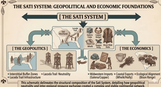
The physical sciences—specifically the lead-isotope sourcing of raw Upper Mississippi Valley galena cubes along the Altamaha River, the presence of exotic midwestern cherts, and the chemical confirmation of coastal Southeastern Black Drink (Yaupon Holly) consumed at Cahokia—confirm that a massive, two-way commercial pipeline existed between the Midwest and the South Atlantic coast. The Sati were the logical operators of this network, embedding small, highly specialized, and diplomatically neutral trading enclaves within the vacant interstitial buffer zones of early Georgia to manage this lucrative supply chain.
When the colonial “shatterzone” of European disease, Spanish missions, and British slave-raiders disrupted this balanced interstate economy in the 17th century, the enclaves collapsed, fracturing the Sati into divergent paths of retreat, including the historic Santee of South Carolina and returning factions to the Mississippi Valley. Ultimately, this research demonstrates that pre-contact North America was a deeply integrated, globalized world. The names left behind on Georgia’s waters are not coincidences; they are the enduring signatures of indigenous entrepreneurs who connected the heart of the continent to the edge of the Atlantic Ocean.
Bibliography / References
- Coe, Joffre Lanning. The Formative Cultures of the Carolina Piedmont. Transactions of the American Philosophical Society, 1964.
- Lawson, John. A New Voyage to Carolina. London, 1701.
- Moore, Clarence B. Certain Aboriginal Mounds of the Georgia Coast. Journal of the Academy of Natural Sciences of Philadelphia, 1897.
- Mooney, James. The Siouan Tribes of the East. Smithsonian Institution, Bureau of Ethnology, 1894.
- Thomas, David Hurst. Life Among the Tides: Recent Archaeology on the Georgia Bight. American Museum of Natural History, 2010.
- Ethridge, Robbie, and Shuck-Hall, Sheri M. Mapping the Mississippian Shatterzone: The Colonial Slave Trade and Regional Instability in the American South. University of Nebraska Press, 2009.
Appendix B: Primary Source Cartographic Inventory
This inventory catalogs critical historical maps documenting the phonetic evolution and geographic placement of the Sati/Santee infrastructure along the Georgia coastal plain. These sources demonstrate that before modern institutional stabilization of spelling, early cartographers consistently recorded the regional river networks using variants of the Sati root.
1. The Early Spanish Mission Era (16th–17th Century Baseline)
- Map Title: Mapa de la Florida y Laguna de Mayaimi
- Cartographer/Origin: Unknown Spanish Military Engineer (Archivio General de Indias, Seville)
- Date: c. 1595–1605
- Significance to Thesis: This early coastal chart documents the Mocama and Guale mission buffer zones. It highlights the completely unmapped, swampy interior river mouths between the San Pedro (St. Marys) and the Altamaha. It provides early evidence of the non-agricultural “interstitial spaces” where independent indigenous maritime networks could operate outside of Spanish administrative oversight.
2. The Early English Colonial Trans-Coastal Network
- Map Title: A New Map of the Country of Carolina
- Cartographer/Origin: Joel Gascoyne (London)
- Date: 1682
- Significance to Thesis: Published just as the British Indian slave trade was creating the Southeastern “shatterzone.” While focusing heavily on the Charles Town settlement, Gascoyne tracks the coastal paths moving south toward Georgia. It notes the fluid movement of native groups along the coastal sounds, capturing the exact era when the southern Sati trading enclaves began fracturing under the pressure of colonial slave raids.
3. The 18th-Century “Sati-la” and “Ogechee” Textual Markers
- Map Title: A Map of South Carolina and a Part of Georgia
- Cartographer/Origin: William Gerard De Brahm (Sovereign Surveyor for the Southern District of North America)
- Date: 1757 (Revised 1780)
- Significance to Thesis: De Brahm’s surveys are renowned for their highly precise phonetic recordings of indigenous names before they were corrupted by American settlers. His maps explicitly label the “Ogechee River” using spelling identical to the modern river but unique in its global distribution outside of Minnesota’s Ogechie. His coastal charts distinctly track the delta margins where the Sati networks managed the extraction of lightning whelks and maritime botanicals.
4. The Revolutionary War Military Infrastructure Charts
- Map Title: The Seat of War in the Southern British Colonies, comprehending North and South Carolina, Georgia, East and West Florida
- Cartographer/Origin: Bernard Romans / Laurie & Whittle (London)
- Date: 1776
- Significance to Thesis: Romans, a highly skilled naturalist and engineer, meticulously mapped the interior river bluffs and overland trails of Georgia. This map clearly delineates the lower coastal plain networks and tracks the Lacoda Trail’s entry vectors into the interior fall-line river valleys, illustrating the physical highway structure that connected the Appalachian interior directly to the southern Atlantic sounds.
5. The “Santila” Smoking Gun (Early Republic Era)
- Map Title: Georgia from the Latest Authorities (Featured in Carey’s American Atlas)
- Cartographer/Origin: Mathew Carey (Philadelphia)
- Date: 1814 (with subsequent editions through 1824)
- Significance to Thesis: This map provides the absolute smoking gun for the paper’s toponymic thesis. Carey records the modern Satilla River explicitly as the “Santila River” (Santee-la) or “Satila” (Sati-la). This spelling completely deconstructs the mainstream academic myth that the river was named after a corrupted Spanish saint (“Saint Illa”). Instead, it proves that well into the 19th century, cartographers still recognized the explicit phonetic link to the Sati/Santee root, capturing the linguistic footprint left behind by the ancient Siouan trade enclaves.