The Tama Network
A Source Audit of Tama/Tamali/Tamahasi, Siouan Parallels, and Possible Mesoamerican Connections
Abstract
Historical sources preserve a recurring series of Indigenous names built around the form Tama across Georgia, South Carolina, western North Carolina, eastern Tennessee, and the Lower Creek country. The earliest securely documented example is the sixteenth- and early-seventeenth-century polity of Tama in interior Georgia. During the upheavals of the seventeenth century, populations carrying the Tama name dispersed into Spanish Florida and the Yamasee world. During the following century, closely related forms appear as Lower Creek towns and clans, Cherokee-country placenames, and names positioned along major Appalachian transportation corridors.
The pattern is difficult to explain as either a chain of accidental resemblances or the movement of one intact village. Hitchiti -a’li and Creek -algi provide plausible collective formations for Tama’li and Tamalgi, while Creek hassi, “old,” provides a plausible explanation for Tamahasi as “Old Tama.” The recurring association of Tama-related names with Oconee, the upper Savannah, Valley River, Hiwassee, and the Little Tennessee suggests a network in which an older political or corporate identity could survive fragmentation, enter new communities, and acquire new linguistic forms.
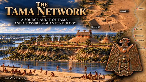
The archaeological and geographical evidence adds a further possibility. The middle Oconee/Fall Line reconstruction of historic Tama, probably at or near the Shinholser site, is supported by Spanish travel accounts, terrain descriptions, and a contact-period occupation at Shinholser. Immediately beside the site, Tomas Lake—a stream or slough entering the Oconee at Big Bend—helps define the floodplain setting of Indian Island and was recorded on the 1916 U.S. Geological Survey as Toms Lake, while the same Oconee corridor also preserves the older Toms Path/Toms Ford naming complex. Shinholser’s unusual pairing of a large rectangular platform mound with a much smaller round mound also recalls paired rectangular and circular/conical mound arrangements at Cahokia. Recent chronological work documents a Cahokian diaspora through the Middle Cumberland and into East Tennessee and northern Georgia during the centuries preceding historic Tama. Combined with the Kansa/Kaw Siouan form ttáma, “town,” these correspondences support the possibility that the Tama network preserves an older Siouan-associated political or settlement tradition.
Introduction
In 1900, James Mooney drew attention to an unusual name occurring more than once in the historic Cherokee country. One Tama’li was located on Valley River a few miles above present-day Murphy, North Carolina, near modern Tomotola. Another stood on the Little Tennessee River near Tomotley Ford in eastern Tennessee. Mooney could not translate the name as Cherokee. Instead, he observed that the Creek also possessed a town called Tama’li on the lower Chattahoochee and suggested that the Appalachian name might therefore have originated outside Cherokee (Mooney 1900:534).
The mystery is not confined to those two Cherokee-country settlements. Tamali or Tamathli appears repeatedly among Lower Creek communities. Tomatly occurs among the Yamasee of coastal South Carolina. Tamahasi, rendered Tamassee in English, appears in the Lower Cherokee country of South Carolina and again on the upper Little Tennessee in western North Carolina. Seventeenth-century English records add the Tomahitans, a population moving through the long-distance Appalachian trade system. Behind these later forms stands an earlier, securely documented polity called Tama in interior Georgia.
Phonetic similarity alone cannot demonstrate historical connection. European scribes rendered unfamiliar Indigenous sounds inconsistently, unrelated words sometimes converge in form, and the Southeast was a region of extensive linguistic borrowing. The significance of the Tama forms lies instead in the intersection of chronology, geography, social organization, and morphology.
The question, therefore, is not whether every Tam-/Tom- name in the Southeast should be forced into a single etymology. It is whether a specific cluster of historically connected names can be explained by the survival and movement of an older political or corporate identity.
This paper proposes that they can. The strongest occurrences form a chronological and geographical sequence: a documented Tama polity in interior Georgia; displaced Tama communities in Spanish Florida and the Yamasee world; Tamali and Tamalgi in the Lower Creek sphere; Tama’li and Tamahasi in the southern Appalachians; and repeated associations with river valleys, trails, crossings, and exchange corridors. The result is best understood as a Tama network rather than as the history of one town.
The Earliest Tama: A Name Before the Network
The documentary trail begins with the political landscape encountered by the Hernando de Soto expedition in 1540. The expedition narratives preserve forms including Altamaca, Altamaha, and related spellings for a town, chief, or political subdivision associated with the Oconee-Ocute world of interior Georgia (Clayton, Knight, and Moore 1993; Swanton 1922).
By the end of the sixteenth century Spanish records increasingly use the shorter form Tama. The 1597 expedition of Pedro de Chozas and Gaspar de Salas reached Tama and neighboring Ocute, while Juan de Lara returned to the same interior region in 1602 and referred to the provincial capital as Olatama or Tama. Additional expeditions during the 1620s continued to use the same political geography (Worth 1994).
Three facts matter for the later history of the name. First, Tama was already an established political identity before the eighteenth-century Creek and Cherokee settlements bearing related forms. Second, it stood within a developed transportation system connecting the Atlantic coast with the interior. Third, the political landscape in which the name originated was broken apart during the seventeenth century. The subsequent history of Tama is therefore a history of what happened to a name after the polity that first carried it ceased to remain intact.
Fragmentation and the Movement of the Tama Name
Warfare, epidemic disease, colonial competition, and the expansion of Indigenous slave raiding destabilized the Georgia interior during the seventeenth century. Westo or Chichimeco attacks were particularly disruptive to the surviving chiefdoms associated with Tama and neighboring Ocute.
The result was not a single migration. Populations dispersed in several directions and entered different political systems.
By 1675, Tama communities were documented far from the earlier Oconee homeland. A Spanish mission list for Apalachee records Candelaria, inhabited by “La Tama and Yamassee,” while a separate enumeration placed a settlement called La Tama on Amelia Island. The Amelia Island community contained about fifty inhabitants and formed part of a larger concentration of recently arrived Yamasee settlements (Hann 1988:35–37).
The name continued to function as an ethnopolitical designation. Swanton cited a 1717 reference to “a Christian Indian named Augustin, of the nation Tama of Apalachee,” demonstrating that Tama could identify a person or population independently of residence in the original Georgia settlement (Swanton 1922:183).
This distinction is fundamental. By the later seventeenth century, Tama was demonstrably a portable identity.
The later recurrence of the name therefore does not require the survival of one village on one river. Populations carrying the name could divide, enter Spanish missions, join developing confederacies, or establish new settlements while continuing to identify themselves through an older political affiliation.
Tama Names in the Yamasee and Creek Worlds
The Yamasee settlement system provides an early illustration of this multiplication. In coastal South Carolina, the Yamasee were divided into Upper and Lower towns composed of populations with different histories. Altamaha became an important Lower Yamasee settlement, while Tomatly appears among the Upper Yamasee.
The coexistence of these two names is important because it argues against a simple sequence in which one Tama settlement merely moved and changed spelling. If the names belong to the same broader naming tradition, related communities were capable of existing simultaneously.
The Lower Creek evidence is even clearer.
By the eighteenth century, Tamali/Tamathli appears within the Lower Creek world. Swanton records Tamatlé on the 1733 De Crenay map, while Spanish records distinguish Old Tamali and New Tamali in 1738 (Swanton 1922:183–184).
The Old/New distinction demonstrates that the name could be reproduced through town fission, resettlement, or political subdivision. A Tama-derived identity did not have to remain attached to one geographical point.
The same phenomenon is widely documented elsewhere in the Southeast. Indigenous towns were corporate communities capable of relocating while retaining their names, and older towns frequently generated new settlements that preserved some element of the parent identity.
This political background becomes essential when the same Tama forms appear in the southern Appalachians.
Tama’li: A Hitchiti Collective
The morphology of Tama’li provides one of the strongest linguistic links in the Tama network. Albert Gatschet documented the Hitchiti collective suffix -a’li, used to identify a class or body of people. His examples include Hitchiti míki, “chief,” becoming miká’li, “the class of chiefs,” while Maskóki becomes Maskoká’li, “the Creek people” (Gatschet 1884:81).
Swanton applied this morphology directly to the historical Tamali. He observed that the Tamali lived among communities belonging to the Hitchiti linguistic group and concluded that the final element of their name probably represented Hitchiti -ali. He further regarded the earlier Spanish Tama as “almost certainly identical” with Tamali (Swanton 1922:183–184).
The resulting formation is straightforward:
Tama + Hitchiti -a’li ? Tama’li
The name can therefore be understood approximately as “the Tama people,” “the Tama group,” or “the Tama collective.” This interpretation does not require the sixteenth-century population called Tama to have originally spoken Hitchiti. It instead shows how an older proper name could be preserved while acquiring Hitchiti morphology after its bearers entered a Hitchiti-speaking political or social environment.
Tama’li therefore preserves the older Tama stem while showing that the identity had become linguistically adaptable. A closely related development appears in Creek social organization, where a Tama-like name survived not as a town but as a clan designation: Tamalgi.
Tamalgi: Corporate Identity, Corn, and Hitchiti Tradition
A corresponding development appears in Creek clan organization. Gatschet recorded Ítamalgi/Támalgi as a Creek clan or gens (Gatschet 1884:155). Creek -algi, like Hitchiti -a’li, functions as a collective element, making the relationship between the two forms particularly suggestive:
Tama + Hitchiti -a’li ? Tama’li
Tama + Creek -algi ? Tamalgi
Swanton likewise recognized the resemblance between the historical Tamali people and the Tamalgi clan, although he cautioned that pronunciation alone could not establish historical identity (Swanton 1922:183–184). The clan form is nevertheless important because it shows how the Tama identity could persist independently of any single settlement. In Creek society, clan affiliation followed maternal descent and could survive changes in residence and political affiliation. A corporate descent group could therefore move between towns or enter a new community while retaining its inherited identity (Swanton 1928).
An especially important association appears in Creek oral tradition. In “The Origin of Corn,” recorded by John R. Swanton from Jackson Lewis, corn was obtained through a woman of the Tamalgi clan. She possessed several kinds of maize and ultimately instructed the people how to plant the grains, after which corn became a permanent part of their subsistence (Swanton 1929:9–10). The Tamalgi woman therefore functions as a culture-bringer, transmitting not merely corn but the knowledge required to cultivate it.
The tradition becomes particularly interesting when compared with the archaeological history of maize in Georgia. The Rush site (9FL164) on the Etowah River near Rome produced the earliest securely dated maize presently recognized in northern Georgia. A directly dated maize cupule yielded an age of approximately A.D. 660 ± 100, with later calibration placing it broadly within the seventh through ninth centuries (Wood and Ledbetter 1990:146; Espenshade 2008). The specimen cannot confidently be assigned to a named prehistoric maize variety, but its location is significant: maize had reached the Etowah River corridor several centuries before the rise of the great Mississippian center at Etowah.
The Rush maize cannot be assigned ethnically to the Tamalgi, and the later Creek origin tradition cannot identify the people who first carried maize into Georgia. The convergence is nevertheless notable. A corporate group bearing the Tama/Tamalgi name was remembered as transmitting maize and the knowledge of its cultivation, while Georgia’s earliest securely dated maize appears in the Etowah River drainage. Because maize ultimately originated in Mesoamerica, its presence in Georgia also reflects a much older history of transmission and exchange extending far beyond the region.
The later association of Tama’li with Hitchiti-speaking peoples adds another dimension. Hitchiti migration traditions preserve a distinct account of their own movement. Gatschet recorded from the Hitchiti informants Chicote and G. W. Stidham that their ancestors first appeared from a canebrake near the seacoast. They traveled inland until they reached a large lake that some initially mistook for the sea, and then continued up a stream before establishing a permanent settlement (Gatschet 1884:77–78).
Immediately following this account, Gatschet recorded another Hitchiti tradition stating that their people were the first to settle at the site of Okmulgi town (Gatschet 1884:78). This claim anchors Hitchiti historical memory directly in the Ocmulgee/Okmulgee landscape of central Georgia. Read together, the traditions preserve a sequence beginning near a seacoast, continuing to a large inland body of water and upstream movement, while also claiming an ancestral presence at ancient Okmulgee.
A separate Hitchiti tradition recorded by Swanton from Jackson Lewis preserves another important distinction. In that account the ancestors of the Hitchiti, identified by their earlier name A’tcik-h?’ta, traveled eastward until they reached the Atlantic Ocean. The Muskogee later came to the place where the Hitchiti were living, after which the two peoples made peace and became allies somewhere in Florida (Swanton 1922:172–173). The tradition therefore remembers the Hitchiti and Muskogee as distinct peoples with separate histories who later entered into an alliance; it does not portray them as a single ancestral population from the beginning.
Taken together, these strands make Tamalgi considerably more important than a simple resemblance between names. Tama’li appears within the Hitchiti-speaking world; Tamalgi survives as a corresponding Creek clan identity; Creek oral tradition credits a Tamalgi woman with transmitting corn and the knowledge of its cultivation; early maize appears in the Etowah River corridor; and Hitchiti traditions preserve both a coastal-to-inland migration and an ancestral claim at Okmulgee. A separate Hitchiti tradition remembers the Muskogee as another people with whom they later became allied.
These traditions do not establish a single continuous migration route. They do, however, provide a plausible mechanism for the persistence of the Tama identity through major political and linguistic changes. A corporate group could move independently of a town, retain an inherited name, enter new alliances, and establish itself within communities speaking other languages. In such a process, Tama could survive as Tama’li within the Hitchiti world and as Tamalgi within later Creek clan organization while related Tama names continued to appear elsewhere in the Southeast.
That possibility becomes especially important when Tama’li appears again farther north along the Valley River, Hiwassee, and Little Tennessee corridors.
Tama’li in the Southern Appalachians
Mooney recorded two principal places called Tama’li in Cherokee country. One stood on Valley River near present-day Murphy, North Carolina; the second lay on the Little Tennessee River near Tomotley Ford in eastern Tennessee. He could not translate the name as Cherokee and explicitly compared it with the Lower Creek Tama’li (Mooney 1900:534).
The Valley River settlement occupied a strategically important location. Valley River flows southwest into the Hiwassee at Murphy, connecting western North Carolina with the Hiwassee basin, north Georgia, and ultimately the Tennessee River system. Long before the historic Cherokee occupation, these valleys contained substantial Indigenous settlements representing successive archaeological traditions.
The name appears early in the surviving eighteenth-century documentary record. In 1725, Colonel George Chicken recorded Tamantley among the towns represented at a council at Tanasi, grouping it with Elejoy, Cheeowee, and Conustee as towns “on the other side the hills.” During the same journey he recorded forms such as Tamautley while traveling through the eastern settlements. The records demonstrate that a Tama’li-like name was already established east of the Overhill country during the 1720s.
The Little Tennessee Tama’li, later rendered Tomotley, occupied another major river corridor within the Overhill Cherokee landscape. The Little Tennessee contained Chota, Tanasi, Toqua, Citico, Tuskegee, and other important towns, and Tomotley Ford was a natural crossing within this densely settled region.
The existence of Tama’li in Cherokee country does not require a Cherokee etymology. Proper names can retain morphology from the language in which they were formed after the people carrying them move into another linguistic environment. Indeed, Mooney’s inability to translate the name from Cherokee is consistent with such a history.
Two broad historical possibilities remain. Appalachian Tama’li communities may represent relocated or incorporated groups carrying a Hitchiti-formed ethnonym northward. Alternatively, they may preserve remnants of a formerly broader distribution of Hitchiti-related populations whose later concentration among the Lower Creeks obscures their earlier northern presence.
The history of Chiaha makes the second possibility particularly important.
Chiaha and the Wider Distribution of Hitchiti-Related Peoples
Hitchiti-related populations were not historically confined to southern Georgia or the lower Chattahoochee.
Swanton classified Hitchiti, Okmulgee, Sawokli, Tamali, and related communities among a Hitchiti-associated or Atcik-hata grouping within the Creek Confederacy. In 1931 he went farther, writing that there was “strong evidence that the Chiaha Indians originally spoke Hitchiti” and that the Mikasuki of Florida had branched from them. His Creek informants associated Chiaha with Hitchiti linguistically, and Swanton regarded Chiaha as having become politically separated from the other Hitchiti-related peoples through an early alliance with Coweta (Swanton 1931).
This is significant because Chiaha appears much farther north in the early historical record. Swanton noted that part of the population was first encountered toward the mountains of Tennessee, and sixteenth-century Spanish expeditions encountered Chiaha within the broader upper Tennessee/Appalachian world before later Chiaha settlements became associated with the Chattahoochee and Creek Confederacy (Swanton 1922:167–169).
The precise language of every sixteenth-century Chiaha community remains debated, and Chiaha should not be used to declare the entire upper Tennessee valley “Hitchiti territory.” Its value is narrower but important: the historical distribution of Hitchiti-related peoples was substantially wider than the location of their later Lower Creek towns.
Accordingly, the occurrence of a Hitchiti-formed Tama’li in western North Carolina or eastern Tennessee is not inherently anomalous. The name could have been transferred into Cherokee territory, or it could preserve the history of a population whose linguistic and political affiliations predated the later Cherokee-Creek boundary.
Tamahasi: “Old Tama”?
The second Appalachian naming pattern occurs farther east.
The Cherokee Nation geographical dictionary preserves the form Tamahasi for Tamassee. It identifies one location on Tomassee Creek in present-day Oconee County, South Carolina, and another on the Little Tennessee River near the mouth of Burningtown Creek in Macon County, North Carolina. The same name therefore occurs on opposite sides of the southern Appalachian divide (Cherokee Nation 2018).
Earlier sources preserve forms consistent with the same pronunciation. James Adair, writing from extensive experience among Southeastern peoples, referred to Tymáhse, a Lower Cherokee town. Mooney later recorded variants including Tomassee, Timossy, and Tymahse while stating that the correct form and interpretation were unknown to him (Adair 1775; Mooney 1900).
Creek provides a plausible explanation for the second element.
Gatschet analyzed Creek Tálisi/Tallassee as a contraction of itálua hássi, literally “Old Town.” He also recorded Tálua mutchási, “New Town,” demonstrating that “old” and “new” could function as relational settlement designations (Gatschet 1884:145).
Modern Creek linguistic description confirms the same element. Jack Martin and Margaret Mauldin give Tvlvhasse, “old tribal town,” while distinguishing the similar but separate Creek word hvse, “sun” (Martin and Mauldin n.d.).
This provides a plausible morphological analysis:
Tama + hassi/ahassi ? Tamahasi
approximately:
“Old Tama.”
No surviving early source has yet been identified in which a Native speaker explicitly translates Tamahasi as “Old Tama,” so the interpretation should not be presented as a recorded historical gloss. It is nevertheless supported by three independent lines of evidence: the preserved form Tamahasi/Tymahse retains the medial h; Creek hassi is a documented word meaning “old” in settlement terminology; and contraction of hassi in town names is directly demonstrated by itálua hássi ? Tálisi.
The likely meaning of “old” also deserves care. In Creek usage, hassi need not mean simply ruined or abandoned. Hawkins recorded functioning communities bearing Old Town names, and Creek political organization distinguished older settlements from dependent or newer villages. His records describe mother towns and associated villages that shared political and ceremonial relationships, while Old Town/New Town distinctions could exist within the same broader identity (Hawkins 1848; Hawkins 1916).
Thus “Old Tama” could carry the practical sense of an older or senior Tama settlement, especially when contrasted with newer branches, without requiring hassi itself to mean “mother,” “original,” or “ancestor.”
This distinction is important. The morphology does not literally say “descendants of the original Tama.” But within a political system in which towns divided and reproduced themselves, an “Old Tama” could plausibly function as the senior Tama community relative to later Tama settlements.
The duplicated geographical form makes that possibility especially intriguing. One Tamahasi stood in the upper Savannah/Lower Cherokee sphere; another stood across the mountains in the upper Little Tennessee drainage. The distribution parallels the duplicated Tama’li pattern farther west.
Oconee and Tama: A Repeated Association
The South Carolina Tamahasi distribution contains another historical correspondence that may bear on the movement of older political identities. The significance does not derive from the modern name Oconee County, which is much later, but from the Indigenous town of Oconee itself. In 1608, Spanish governor Pedro de Ibarra referred to “the chief of Ocone which marches on the province of Tama,” indicating that Ocone and Tama occupied adjoining political territories in the early seventeenth-century Georgia interior (Swanton 1922).
More than a century later, the two names appear together again in the Cherokee Lower Town landscape of western South Carolina. Oconee was recorded in early eighteenth-century forms including Oakenni and Acconne, while George Hunter’s 1730 map places Acconne and Tomassee among the Lower Towns of the Keowee drainage. Historical reconstructions place Oconee and Tomassee only a few miles apart within the same network of towns and trails (Hunter 1730).
The South Carolina Oconee name has generally been treated as Cherokee. Mooney recorded the Cherokee form Ukwu’nu or Ukwu’ni, but did not provide a transparent Cherokee etymology for it. Swanton consequently left open two possibilities: that the resemblance to the historical Muskogean Oconee was coincidental, or that the South Carolina name preserved evidence for a more northerly branch of the Oconee people (Mooney 1900; Swanton 1952).
The latter possibility is especially relevant because the historical Oconee belonged to the Hitchiti-related or Atcik-hata grouping within the Creek world, placing them in the same broader linguistic and political sphere as Tamali. The comparison therefore involves more than two isolated look-alike placenames: an Ocone community adjoining Tama in the Georgia interior is followed, more than a century later, by an Oconee community adjoining Tamahasi in the South Carolina foothills.
No surviving document states that Oconee and Tama populations migrated north together, and the recurrence cannot be treated as proof of a joint migration. Its specificity nevertheless makes it historically significant. The repeated association—Ocone with Tama in the early seventeenth-century Georgia interior, and Oconee with Tamahasi in the early eighteenth-century Lower Town landscape—supports the broader possibility that portions of the later Cherokee foothill settlement system incorporated older corporate populations and place-names whose histories preceded the eighteenth-century Cherokee-Creek political boundary.
Two Appalachian Corridors
When these names are placed geographically rather than treated separately within later tribal histories, two broad corridors become visible.
An eastern corridor links:
Tamahasi/Tamassee in South Carolina ? upper Savannah and Tugaloo ? Appalachian crossings ? Tamahasi on the upper Little Tennessee.
A western corridor links:
north Georgia ? Valley River ? Tama’li near Murphy ? Hiwassee ? Tama’li/Tomotley on the Little Tennessee.
These should not be imagined as single fixed roads. Indigenous transportation systems consisted of intersecting trails, river routes, passes, seasonal alternatives, and political nodes. The importance of the pattern lies in the fact that the names occur within genuine, historically utilized corridors rather than forming an arbitrary scatter of similar syllables.
The distribution also resembles other Southeastern names that cross later political boundaries. Tuskegee appears both in Creek country and on the Little Tennessee. Coosa-associated names extend through north Georgia and adjacent mountain regions. Chattooga and related forms occur in multiple watersheds.
Such patterns caution against projecting eighteenth-century Creek and Cherokee territorial boundaries unchanged backward into the sixteenth century.
The southern Appalachians were a zone of long-term population movement and political recombination. Tama’li and Tamahasi may preserve part of that earlier social geography.
The Tomahitans and Long-Distance Exchange
A related seventeenth-century ethnonym appears within the Appalachian trade network. In 1673, Virginia trader Abraham Wood dispatched James Needham and Gabriel Arthur westward in an attempt to establish direct trade beyond the Piedmont. They encountered a large party described in Wood’s account as Tomahitans or Tomahittans moving between the mountain interior and the Occaneechi trading sphere. Some continued eastward toward Virginia while Needham and Arthur traveled west with others to their home community (Alvord and Bidgood 1912).
The ethnic identity of the Tomahitans has never been securely resolved. Swanton associated the later Tamahita name with Yuchi populations, while other researchers have proposed a Hitchiti-related group connected with the Ocute world. David Kaufman instead places the name within an Ohio Valley Siouan context and argues that the Tomahitans were related to the broader population from which the historic Biloxi emerged (Swanton 1952; Kaufman 2018).
The linguistic analysis is particularly relevant to the Tama problem because the apparent ending -hitan is unlikely to be a standalone suffix. Kaufman interprets Tomahitan as a Siouan compound built from a town term comparable to t?m?/tama and ith?, “big” or “great,” yielding approximately “Big Town” or “Great Town.” The second element belongs to a well-attested Ohio Valley Siouan word family for “big, great,” and the final n in English spellings may represent an attempt to record a nasal vowel rather than a discrete Native suffix (Rankin et al. 2015; Kaufman 2018).
This interpretation does not establish that the Tomahitans themselves were Biloxi or even that they spoke a Siouan language; the historical identity of the population remains disputed. It does, however, provide a substantially stronger linguistic explanation of the name than an otherwise unattested Cherokee, Creek, or Hitchiti suffix -hitan.
If the analysis is correct, Tomahitan differs structurally from Tama’li and Tamahasi. Rather than an older Tama identity receiving Hitchiti or Creek morphology, the name would represent a Siouan compound constructed with the broader tama-type settlement term. Its value for the present argument is therefore not proof that the Tomahitans descended from the Georgia Tama polity, but evidence that a closely related “town” element was active within the seventeenth-century Appalachian exchange world and could participate in different linguistic formations.
The Pattern Takes Shape: A Tama Network
By this point the evidence can be understood as a series of overlapping historical processes rather than a list of similar-sounding placenames.
The first is continuity. Tama is a documented sixteenth- and seventeenth-century political name, not a root reconstructed only from later forms.
The second is dispersal. Tama populations appear outside the Georgia homeland in Spanish Florida, while Tama continues to function as an ethnopolitical affiliation detached from a single settlement.
The third is replication. Altamaha, Tomatly, Old Tamali, and New Tamali demonstrate that related names could coexist in separate communities rather than representing one village moving intact from place to place.
The fourth is corporate survival. Tamalgi/Tamali occurs as a clan or collective identity, showing that the name could attach to a social body as well as to a town.
The fifth is Appalachian distribution. Tama’li appears on Valley River and the Little Tennessee, while Tamahasi appears on both the upper Savannah side and the upper Little Tennessee side of the mountain divide.
The sixth is linguistic adaptation. Hitchiti -a’li, Creek -algi, and Creek hassi provide plausible mechanisms by which an older Tama name could be remodeled inside later Muskogean-speaking political communities without requiring the root itself to have originated in those languages.
The seventh is geographical continuity. Ocone adjoined Tama in the early seventeenth-century Georgia interior; more than a century later Oconee and Tomassee appear together in the Lower Cherokee town landscape. The eastern and western Appalachian occurrences also lie along real river-and-trail corridors rather than forming a random scatter.
No single strand establishes that every form derives from one ancestral population. Together, however, they describe a coherent process: a political name survives fragmentation, becomes portable, enters multiple communities, acquires new morphology, and remains visible along the routes through which people and goods moved.
That process is the Tama network. Once the network is recognized, the location and character of the original Georgia center become important not as the subject of the paper, but as a test of the larger hypothesis.
The Georgia Anchor: Why Shinholser Matters
The precise archaeological location of late-sixteenth-century Tama has been debated. Marvin T. Smith proposed the Shinholser site (9BL1) on the Oconee near the Fall Line; Samuel J. Lawson III and Frankie Snow placed Tama farther south in the Ocmulgee-Oconee Forks region; and Mark Williams, after excavating Shinholser, considered the question unresolved (Smith 1987:15-17; Lawson 1987; Snow 1990; Williams 1990:157-159). John Worth later reconstructed the Spanish routes in favor of the middle Oconee/Fall Line region and treated the southern Forks polity as more likely Utinahica/Santa Isabel (Worth 1994, 1995). The present argument follows the middle Oconee model because several independent lines of evidence converge there.
The travel accounts provide the first line. The 1597 party required roughly eight days to reach Tama from the Guale coast. In 1602 Juan de Lara described approximately nine full days of travel and said that he arrived at a sierra where Olatama stood. Other descriptions associate Tama with hills, highlands, minerals, and crystals. Those accounts fit the transition into the Oconee Fall Line and Piedmont far better than the low-relief Coastal Plain around the Forks (Worth 1994).
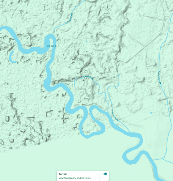
A second line comes from the relative geography recorded in 1630. Juan Fernandez de San Agustin placed Tama about fifty leagues inland, then placed Santa Isabel roughly thirty leagues farther to the southwest and Harapaha beyond it. Spanish compass bearings were approximate, but the sequence requires Tama and Santa Isabel to be distinct interior provinces. A middle-Oconee Tama with Santa Isabel/Utinahica farther downstream toward the Altamaha drainage fits that sequence more readily than placing Tama itself at the Forks (Worth 1995).
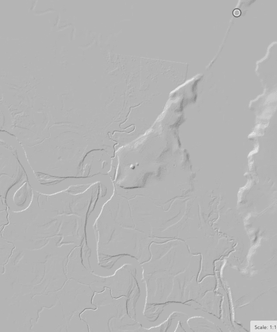
Shinholser also fits the archaeological window. Williams found the site to be the largest known Mississippian settlement in the Oconee Valley, extending over more than forty acres. It was occupied during the Savannah period, abandoned for part of the Lamar sequence, and resettled around A.D. 1500, when it again became a major community. The later occupation continued into the contact period and produced Spanish material (Williams 1990). That does not prove that Shinholser was Tama, but it supplies an archaeological center of the correct scale, date, and location for the town described in the Spanish accounts.
The identification is therefore best stated as a working historical reconstruction: the documentary evidence favors the middle Oconee/Fall Line, and Shinholser is the strongest presently identified archaeological candidate within that landscape.
Tomas Lake, Indian Island, and the Oconee Landing Landscape
Modern Tomas Lake is directly associated with the Shinholser landscape. Despite its name, the Geographic Names Information System classifies Tomas Lake as a stream, and its course enters the Oconee River at Big Bend, immediately beside Indian Island. The U.S. Geological Survey’s Irwinton quadrangle, surveyed in 1916, records the earlier form Toms Lake (U.S. Geological Survey 1920; U.S. Geological Survey n.d.).
Shinholser occupies elevated ground on Indian Island, an erosional remnant within the Oconee floodplain. Williams described the site as rising above surrounding swamp that became inundated during periods of high water (Williams 1990:10–11). Tomas Lake and its associated sloughs form part of the low-lying drainage along the eastern and northeastern side of that elevated landform. During flood stages, those waters would have helped isolate the higher ground from the surrounding floodplain, effectively turning Indian Island into an actual island bounded by the Oconee on one side and inundated sloughs and swamp on the other.
At the southern end of this system, Tomas Lake reaches the Oconee at Big Bend through a broad backwater zone. The precise history of this feature remains uncertain; portions may
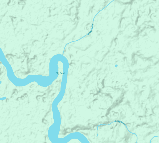
navigable backwater and slough system would have expanded substantially. Although no archaeological evidence presently demonstrates constructed docks or an artificial harbor, the Big Bend–Tomas Lake confluence could have functioned as a large natural canoe harbor and landing zone serving the settlement.
Such a setting is consistent with the broader distribution examined in this paper. Tama-related names repeatedly occur at river crossings, trail junctions, navigable valleys, and other strategic nodes within regional exchange corridors. If Shinholser represents historic Tama, its position at the Georgia Piedmont Fall Line, at the conjunction of elevated settlement ground, the Oconee channel, Tomas Lake, and the Big Bend backwater would place it at exactly the kind of transportation node expected for a community participating in long-distance exchange.
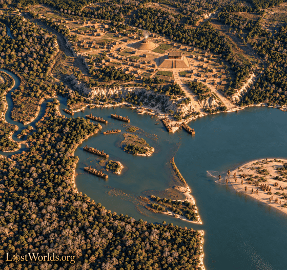
The hydronym adds a separate line of evidence. The identification of Shinholser with Tama was proposed on archaeological and documentary grounds without reference to Tomas Lake. Marvin T. Smith proposed Shinholser as the historical Tama, Mark Williams excavated the site and considered that possibility, and John Worth later reconstructed Tama independently into the same middle-Oconee landscape using Spanish travel accounts, distances, terrain, and political geography. The Tomas/Toms name therefore did not generate the identification.
Its proximity nevertheless deserves attention. The name belongs to the watercourse that helps define the eastern side of Indian Island and enters the Oconee beside the proposed Tama settlement. Its modern form, Tomas, closely resembles Tama, while the 1916 USGS map preserves the earlier form Toms Lake. No evidence presently demonstrates that either form derives from the Indigenous name Tama, but the association is unusually localized: a Tama-like hydronym occurs within the immediate river-and-slough system surrounding the strongest archaeological candidate for historic Tama.
A second naming complex occurs farther upstream. Toms Path was an old Indigenous trail across central Georgia whose Oconee crossing near Milledgeville became known as Toms Ford or Toms Shoals. Robert Flournoy referred to “Old Tom’s path” in 1793, establishing the name by the late eighteenth century (Flournoy 1793). John Goff later discussed several possible personal namesakes but could establish none of them conclusively (Goff 1960). The possessive form Tom’s makes a personal-name origin plausible for the path, ford, and shoals, and they should therefore be treated as a single historical naming complex rather than as independent survivals of Tama.
Tomas Lake presents a different problem. Its name is attached directly to the hydrological system surrounding Indian Island, and no identified personal namesake has yet been demonstrated for it. The earlier Toms Lake spelling prevents the modern form Tomas from being treated as straightforward proof of continuity from Tama, but neither does it explain the coincidence. The safest conclusion is that the name remains an unresolved local toponym whose location makes it particularly relevant to the Shinholser-Tama hypothesis.
Cahokian Connections and a Possible Siouan Founder Population
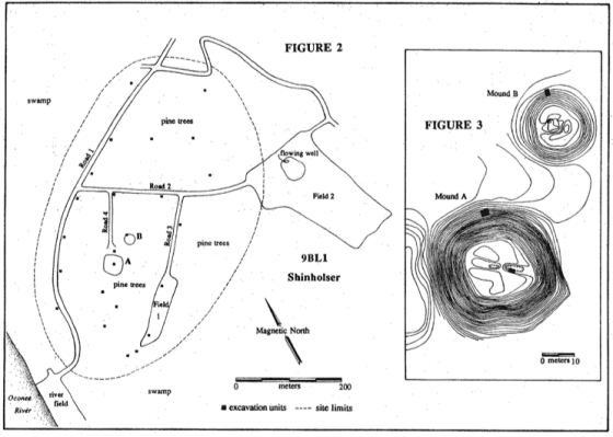
Shinholser’s architecture adds another line of evidence that becomes significant only after the site is placed within the broader Tama network. Williams mapped two mounds standing unusually close together. Mound A is a strongly rectangular platform mound about 7.1 meters high, roughly 40 by 44 meters at the base, with a nearly square summit. Only about 14 meters to its northeast stood Mound B, a much smaller round mound approximately 27 meters in diameter. Williams emphasized that the two were too close for the normal two-mound-and-plaza arrangement found at many Georgia centers (Williams 1990:19-20, 23, 34-35). In fact, had the mounds been enlarged one or two more times they likely would have adjoined.

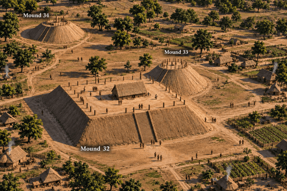
That configuration has a striking parallel at Cahokia. The Cahokia mound complex contained multiple paired arrangements in which a rectangular or square platform mound stood immediately beside a circular or conical mound. Mounds 32 and 33 are especially suggestive: the first was a square, flat-topped platform, while the second stood at its northeast corner and was historically mapped as conical (Fowler 1997). Recent geophysical research has further complicated the old category “conical mound,” showing that some Cahokian examples were actually flat-topped circular platforms associated with circular sweat lodges or rotundas and paired with rectangular structures or mounds (Pauketat et al. 2023).
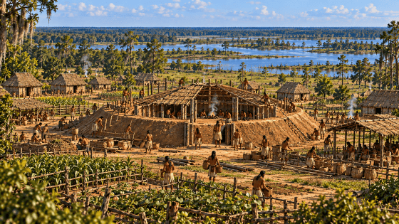
Shinholser’s Mound B may preserve a related architectural history. Williams concluded from the exposed profiles that the mound probably began as a sunken-floor, earth-banked council house or earth lodge and was later filled, flattened, and transformed into a conical mound, perhaps with a mortuary function. He specifically compared its early construction to the Beaverdam Creek mound on the Savannah River, where excavation documented an earth lodge that was later replaced by a structure on a platform mound (Williams 1990:34-35; Rudolph and Hally 1985).
Shinholser also produced material evidence placing the site within the wider Mississippian ceremonial interaction sphere. In 1977, Ed Medlin and Royce Lawrence recovered an intact repoussé copper plate from a burial near the summit of Mound B. The square plate measured approximately 13.7 centimeters on a side and had been placed over the forehead of a crushed skull, apparently as part of an elaborate headdress. Its design depicts a splayed bird, probably a falcon, with outstretched wings and opposed claws. Williams identified it as a Southern Cult-style object and considered it most likely associated with the site’s Savannah-period occupation around A.D. 1300 (Williams 1990:34, 232–233).

Williams further observed that the Medlin plate is remarkably similar to a raptor copper plate from the Lubbub Creek site in northwestern Alabama. The two objects are nearly identical in size and composition and share a central perforation, differing principally in minor details of the wing, breast, tail, and head designs (Williams 1990:232–233; Ensor 1981). Such copper plates belonged to the wider Mississippian ceremonial and iconographic system whose most elaborate manifestations are associated with centers such as Cahokia, Etowah, Moundville, and Spiro. The Medlin plate therefore does not demonstrate that the object itself was manufactured at Cahokia, but it provides independent evidence that Shinholser participated in the same long-distance ceremonial network during the period when Cahokian-derived traditions were spreading through the Southeast.

Neither the mound arrangement, the earth-lodge sequence, nor the Medlin plate can identify the language or ethnicity of Shinholser’s inhabitants. Taken together, however, they place the site within an archaeological world in which Cahokian architectural forms, mortuary practices, ceremonial objects, and iconography were circulating across the Southeast. Shinholser’s first major Mississippian occupation belongs to approximately A.D. 1300. Recent radiocarbon synthesis documents a Cahokian diaspora from the Central Mississippi Valley into the Middle Cumberland and subsequent population movement from the Middle Cumberland into East Tennessee and northern Georgia between roughly A.D. 1200 and 1450 (Sullivan et al. 2024). The timing therefore provides a plausible historical setting in which Cahokia-derived people, institutions, or architectural traditions could have entered the southern Appalachian and Georgia landscape.
The Siouan comparison is likewise suggestive rather than diagnostic. Kansa/Kaw, a Dhegiha Siouan language, preserves ttáma, “town,” and historic Kansa communities used circular earth lodges as semi-permanent village dwellings (Rankin et al. 2015; Kansas Historical Society 2011). The coincidence of a Tama political name, a paired rectangular-and-round mound arrangement with close Cahokian parallels, an earth-lodge sequence, and a documented era of population movement out of the greater Cahokian world permits a specific hypothesis: some of the people who founded or reorganized the Shinholser center may have belonged to a Siouan-speaking or Siouan-associated migrant population ultimately connected to the Cahokian diaspora.
That hypothesis should not be mistaken for an archaeological identification of language. Shinholser was occupied, abandoned, and resettled across several centuries, and the historic Tama encountered by Spaniards around 1600 may have inherited an older ceremonial landscape built by earlier populations. The significance of the Cahokia comparison is therefore cumulative: it shows that the proposed Siouan reading of Tama is compatible with a real archaeological history of migration and with an unusual architectural pattern at the site, rather than resting on a dictionary resemblance alone.
What Did Tama Mean?
The historical development of the name can be reconstructed with considerably greater confidence than its original linguistic meaning. Sixteenth- and early-seventeenth-century documents preserve Tama as the name of an Indigenous polity, but no surviving vocabulary identifies the language spoken by its inhabitants and no contemporary source translates the name. Later Tamali communities were associated with Hitchiti-speaking peoples, yet that later affiliation cannot by itself explain the older root. The linguistic question therefore has to begin with comparison rather than assumption.
The closest known settlement term occurs in Siouan. The Comparative Siouan Dictionary records Kansa/Kaw ttáma, meaning “town” (Rankin et al. 2015:1027). The resemblance to historical Tama is striking both in form and meaning. It does not prove that Georgia Tama meant “town,” nor does it prove that the people of Tama spoke a Siouan language. The dictionary itself complicates such a conclusion by describing the broader term as apparently old but widely diffused, with parallels outside Siouan. That leaves open two possibilities: Tama may preserve Siouan settlement vocabulary, or it may belong to an older regional vocabulary that spread between interacting language communities.
Choctaw immediately demonstrates why that distinction matters. Choctaw támaha, modern tvmaha, also means “town.” Considered alone, this could appear to provide a straightforward Muskogean explanation for Georgia Tama. Gatschet’s comparative vocabulary shows otherwise. Under “Village, town,” he records Choctaw támaha, but Chickasaw ókla, Alabama and Koasati óla, Creek and Seminole tálofa, Hitchiti and Mikasuki ókli, and Apalachee tófun (Gatschet 1884:56). Among the Muskogean languages in his comparison, therefore, támaha occurs only in Choctaw. Most significantly, even Chickasaw, the language most closely related to Choctaw, uses an entirely different ordinary word for “town.”
That pattern makes borrowing or regional diffusion at least as important to consider as inheritance. It also agrees with the Comparative Siouan Dictionary’s warning that the larger tama/tamaha complex crossed linguistic boundaries. The difficult question is not merely whether Choctaw possesses the word—it plainly does—but why Choctaw has it when the other Muskogean languages surveyed by Gatschet do not.
David Kaufman has proposed a possible explanation for how tama-type vocabulary could have moved through long-distance exchange networks. In Papantla Totonac, an entire cluster of commercial terms is built around the tamaw- root. Tamawá means “to buy,” tamawaná’, referring to a buyer or one who acquires goods, liitamaw, “market” or “plaza,” and puutamawan, a “place to buy” or marketplace. The root is therefore not simply embedded in an isolated word for “market”; it belongs to a broader vocabulary of buying and exchange (Aschmann and Aschmann 1973:110; Kaufman 2016:55–56; García Ramos 2006:43).
Their internal structure helps explain how a commercial term could develop into a place-name or settlement term. Totonac lii- is an instrumental prefix, adding the sense of the means or instrument by which an action is carried out, while puu- is locative, marking the place where an action occurs (MacKay 1999:386, 388; Kaufman 2016:56). Totonacan grammatical descriptions show lii- forming instrument nouns from verbs—for example, terms equivalent to scissors from “cut,” a broom from “sweep,” or a writing instrument from “write.” The three forms can therefore be understood approximately as:
tamaw(an) — “to buy”
lii-tamaw — the means or setting associated with buying ? “market / plaza”
puu-tamaw-an — the place where buying occurs ? “place to buy / market”
The semantic development is straightforward. A verbal root meaning “buy” generates nouns referring to the place or setting of exchange. Kaufman therefore suggests that terminology of this kind could have traveled through circum-Gulf trade networks and, in another linguistic setting, broadened from “marketplace” or “trading center” to “town” or “town center.” The proposal does not require Georgia Tama to have been Totonac. Its significance is that it supplies a plausible mechanism by which a commercially useful tama-type term could spread between unrelated language communities through sustained exchange.
Two formal correspondences make Kaufman’s Totonacan comparison especially striking. The first is between Choctaw támaha, “town,” and Totonac tamawá, “to buy”: despite belonging to unrelated language families, the two words are remarkably similar in sound and differ only slightly in their final consonantal element (Gatschet 1884:56; Kaufman 2016:55–56). The second involves Totonac liitamaw, “market” or “plaza,” and Hitchiti Tama’li. The two forms are almost mirror images of one another, with Totonac lii- preceding the tamaw- root and Hitchiti -a’li following Tama. Their morphology is not equivalent—Totonac lii- is an instrumental prefix, whereas Hitchiti -a’li is a collective suffix—and no historical relationship between the affixes can presently be demonstrated (Gatschet 1884:81; MacKay 1999:386, 388; Kaufman 2016:56). Even so, the juxtaposition is noteworthy: támaha/tamawá and liitamaw/Tama’li independently place closely similar tama/tamaw forms within vocabularies of towns, peoples, buying, and marketplaces across otherwise unrelated languages. Considering that Tama-related placenames recur across the Southeast at important nodes within documented or proposed trade corridors, these linguistic similarities are not only striking but also geographically fitting.
Kaufman’s proposal also gives new significance to the unusual Choctaw distribution. The historic Choctaw homeland lay considerably farther south than the Chickasaw homeland, extending through central and southern Mississippi toward the lower Mississippi and Gulf-facing regions, while Chickasaw communities were concentrated farther north (National Park Service n.d.; Chickasaw Nation n.d.). Geography alone cannot demonstrate that Choctaw borrowed támaha through Gulf trade. Yet if a tama-type marketplace term entered Muskogean from a southern or circum-Gulf interaction sphere, the more southerly position of the Choctaw provides a reasonable context for why Choctaw acquired the term while closely related Chickasaw retained ókla.
Archaeology now demonstrates that the scale of interaction required by such a hypothesis actually existed. Ancient DNA recovered from eleventh- and twelfth-century pottery at Etowah in northern Georgia has identified Theobroma cacao, a tropical crop that could not have been grown locally (King et al. 2026). The researchers cannot determine the precise route by which cacao reached Etowah and do not establish direct contact between Georgia and Totonac-speaking Mexico. Nevertheless, the discovery establishes an important fact: centuries before European contact, products originating far to the south were reaching the Mississippian exchange world of northern Georgia. Kaufman’s proposed movement of commercial vocabulary around the Gulf therefore does not depend upon imagining a degree of long-distance interaction for which no material evidence exists.
One additional cultural parallel is worth recalling. As discussed earlier, Muskogee oral tradition credited a woman of the Tamalgi clan with transmitting corn and teaching its cultivation to the people (Swanton 1929:9–10). Because maize itself originated in Mesoamerica, the tradition adds another suggestive—though not demonstrative—association between the Tama/Tamalgi complex and influences ultimately derived from the Mesoamerican world.
A second lexical parallel makes the Totonacan comparison particularly interesting. Papantla Totonac has chiki, “house.” Hitchiti and Mikasuki preserve essentially the same form, Gatschet recording tchíki for “house,” while Apalachee has the closely related tchíka (Gatschet 1884:56; Aschmann and Aschmann 1973). Once again, the comparison is not simply with a universal Muskogean form. Other Muskogean languages in Gatschet’s table use related but different words or entirely different roots.
The possible Mesoamerican significance of this chiki correspondence was proposed in earlier LostWorlds research well before the present Tama study. In 2011, Daniels noted the identity between Hitchiti chikee and Totonac chiki, both meaning “house,” and compared them with a Mayan chiki term (Hull 2016) for a woven basket (Daniels 2011).
The argument was developed more fully the following year in Mayan Words Among Georgia’s Indians? Daniels proposed that the semantic connection involved both construction and the broader Mayan conception of a dwelling as a container. Classic Maya otot meant “house” or “home,” but the same term could also be applied metaphorically to ceramic containers as the “home” of their contents; small vessels, for example, could be identified as the otot of the substance they contained.
Against that semantic background, the Mayan chiki’, “woven basket,” and Totonac and Hitchiti chiki, “house,” become more readily comparable. A basket is a container made from interlaced vegetal material, while traditional Totonac and Southeastern dwellings could likewise be constructed from interwoven saplings, cane, reeds, or mats. Daniels therefore proposed that chiki may have moved semantically from a woven container to a woven dwelling—or reflected a conceptual category in which a house itself could be understood as a type of container (Daniels 2011, 2012).
Thus chiki supplies a second striking correspondence between Totonacan and Southeastern vocabulary, while the Mayan basket term offers a previously proposed semantic explanation for how “woven container” and “house” could become associated.
The parallel becomes more suggestive when considered alongside tama. Kaufman’s Totonac comparison concerns a word associated with commerce and the marketplace; chiki concerns the house or built environment. These are not obscure ceremonial terms but basic elements of settled community life. The evidence does not require Totonac colonization of the Southeast, nor does it demonstrate that either word moved directly from Veracruz to Georgia. Long-distance exchange normally works through chains of intermediaries, and loanwords can travel much farther than the people who first coined them.
Taken together, the linguistic evidence resists a simple ethnic explanation. Kansa/Kaw ttáma, Choctaw támaha, Totonacan marketplace terminology built around tama-, and the recurring chiki forms may ultimately have different histories. But they are also consistent with an older interaction sphere in which vocabulary moved alongside goods, people, and political identities. The anomalous distribution of támaha inside Muskogean, Kaufman’s proposed Gulf-coast commercial source, the more southerly position of the Choctaw, the independent chiki correspondence, the Tamalgi tradition associating that corporate identity with the transmission of maize, and the physical presence of cacao at Etowah all make such diffusion increasingly plausible.
None of this establishes that Georgia Tama was Totonac, Choctaw, or Siouan. It suggests instead that Tama may have belonged to an older vocabulary of settlement and exchange whose movement across linguistic boundaries mirrored the movement of people and goods through the same networks. If so, a community could inherit the name without inheriting the language in which it was first coined.
That possibility fits unusually well with the historical behavior of the Tama name.
Older Root, Later Morphology
The chronological sequence permits a useful distinction between the root and the later forms attached to it.
The earliest documentary evidence gives Tama.
Later Hitchiti-associated sources give Tama’li, analyzable as:
Tama + collective -a’li
Later Creek social organization preserves Tamalgi, analyzable through the corresponding Creek collective -algi.
The Appalachian form Tamahasi can plausibly be analyzed through Creek hassi, “old”:
Tama + hassi ? Old Tama
These formations do not require the root to have originated in either Hitchiti or Creek.
Instead, they may record the process by which an older political identity was naturalized within new linguistic systems.
This distinction is particularly important in the Indigenous Southeast, where displaced communities were repeatedly absorbed into larger confederacies. A group could preserve an inherited proper name while adopting the morphology, language, and political institutions of its new neighbors.
Under such circumstances, the later linguistic form tells us how the identity survived—not necessarily where it began.
A Methodological Control: Tomoka
Not every southeastern Tam-/Tom- name belongs to the Tama network.
Florida’s Tomoka River provides an instructive example.
Tama populations were genuinely present in northeastern Florida during the seventeenth century, including the documented La Tama settlement on Amelia Island. On superficial phonetic grounds alone, Tomoka might therefore appear to be another Tama derivative.
The documentary history points in another direction.
When Álvaro Mexía described the present Tomoka area in 1605, he called the bay and settlement Nocoroco. The recorded Indigenous community was Timucua, and there is no early Tama hydronym at the location (Griffin 1948).
Later British spellings of the modern river include forms much closer to Timucua/Atimucua, such as Timouka and Tomoko. No evidence has been identified placing a displaced Tama population in the Tomoka basin.
Tomoka is therefore better treated as a Timucua-derived name rather than as part of the Tama complex.
The example establishes an important methodological principle: phonetic resemblance is useful for identifying candidates, but membership in the Tama network requires supporting historical, linguistic, geographical, or social evidence.
Conclusion
The recurring Tama names of the Southeast are best understood as evidence of continuity through change.
The sequence begins with a documented political name in sixteenth- and early-seventeenth-century interior Georgia. During the seventeenth century, warfare, disease, slave raiding, and colonial disruption fragmented that political landscape. Tama populations then appear outside the original homeland in Spanish Florida and the Yamasee world, demonstrating that the name could travel with people.
During the following century the name multiplied rather than disappeared. Tamali appears among Hitchiti-associated Lower Creek communities and divides into Old and New towns. Tamalgi survives as a clan or collective identity. Tama’li appears on Valley River and the Little Tennessee. Tamahasi appears on both sides of the Appalachian divide. The repeated Ocone-Tama and Oconee-Tamahasi association adds another indication that older political relationships may have survived inside later settlement systems.
The morphology explains how that could happen. Hitchiti -a’li and Creek -algi allow an inherited proper name to become a collective identity; Creek hassi provides a plausible mechanism for “Old Tama.” These later formations can tell us how the name survived without telling us which language originally created the root.
The geography supplies the framework. Tama-related names repeatedly occur along the Oconee, upper Savannah, Valley River, Hiwassee, and Little Tennessee systems and within historically important trail networks. The distribution therefore resembles a network of connected political and exchange nodes more than an accidental scatter of syllables.
The Georgia evidence strengthens that interpretation. Spanish itineraries and terrain descriptions favor a middle-Oconee/Fall Line location for the historic Tama, with Shinholser as the strongest archaeological candidate. Tomas Lake, the stream/slough entering the Oconee at Big Bend beside Indian Island, its earlier Toms Lake spelling, and the Toms Path/Toms Ford complex farther up the same Oconee corridor do not prove survival of the Tama name, but they add a localized naming pattern that previous Shinholser discussions appear not to have considered.
Shinholser’s mound plan also opens a deeper possibility. Its close pairing of a rectangular platform mound and a smaller round mound resembles paired mound arrangements at Cahokia, while Mound B appears to have begun as an earth-banked council house or earth lodge. Recent archaeology independently documents population movement from the Cahokian world through the Middle Cumberland and into East Tennessee and northern Georgia during the centuries when Shinholser first developed as a Mississippian center. Those facts do not identify the inhabitants as Siouan, but they make a Siouan-associated migrant hypothesis archaeologically plausible.
The linguistic root remains unresolved. Kansa/Kaw ttáma, “town,” offers a close Siouan comparison; Western Muskogean tamaha and Kaufman’s proposed Totonacan marketplace vocabulary point instead toward a wider history of borrowing and exchange. The most productive conclusion is therefore not that one dictionary has solved the name, but that Tama may belong to an older settlement and exchange vocabulary capable of crossing linguistic boundaries.
The Tama distribution is therefore best understood neither as the route of one intact migrating tribe nor as a collection of unrelated coincidences.
It is a network.
Within that network, a political name could become an ethnonym, an ethnonym could become a clan identity, a clan could move independently of a town, a senior settlement could be distinguished from a newer branch, and an inherited name could survive after the people carrying it entered a community speaking another language.
What survives in Tama, Tama’li, Tamalgi, Tamahasi, and the associated Oconee and Appalachian geography may be fragments of a political landscape older than the Creek-Cherokee boundary through which the Southeast has usually been reconstructed.
References
Adair, James. 1775. The History of the American Indians. London: Edward and Charles Dilly.
Alvord, Clarence Walworth, and Lee Bidgood. 1912. The First Explorations of the Trans-Allegheny Region by the Virginians, 1650-1674. Cleveland: Arthur H. Clark Company.
Aschmann, Herman P., and Elizabeth D. Aschmann. 1973. Diccionario totonaco de Papantla, Veracruz: Totonaco-español, español-totonaco. Serie de Vocabularios y Diccionarios Indígenas “Mariano Silva y Aceves,” no. 16. México: Instituto Lingüístico de Verano.
Cherokee Nation. 2018. Cherokee-English Dictionary. Tahlequah, Oklahoma: Cherokee Nation Language Program.
Chickasaw Nation. n.d. “Homeland.” Chickasaw Nation.
Clayton, Lawrence A., Vernon James Knight Jr., and Edward C. Moore, eds. 1993. The De Soto Chronicles: The Expedition of Hernando de Soto to North America in 1539-1543. 2 vols. Tuscaloosa: University of Alabama Press.
Crane, Verner W. 1929. The Southern Frontier, 1670-1732. Durham, North Carolina: Duke University Press.
Daniels, Gary C. 2011. “Fort Mountain Stone Wall (400 AD).” LostWorlds.org, February 21, 2011.
Daniels, Gary C. 2012. “Mayan Words Among Georgia’s Indians?” LostWorlds.org, January 3, 2012.
Espenshade, Christopher T. 2008. Woodland Period Archaeology of Northern Georgia: Update 2008. Atlanta: Georgia Department of Transportation.
Flournoy, Robert. 1793. Letter to James Seagrove, October 5, 1793. Papers of the War Department, 1784-1800, document 1793100560050. National Archives and Records Administration.
Fowler, Melvin L. 1997. The Cahokia Atlas: A Historical Atlas of Cahokia Archaeology. Revised ed. Studies in Archaeology No. 2. Urbana: Illinois Transportation Archaeological Research Program, University of Illinois.
García Ramos, Crescencio. 2006. Manual de fonética totonaca: Pumakaskujni ixli’aksanat tutunakú: El Tajín, Papantla, Veracruz. Xalapa, Veracruz: Secretaría de Educación de Veracruz.
Gatschet, Albert S. 1884. A Migration Legend of the Creek Indians, with a Linguistic, Historic and Ethnographic Introduction. Vol. 1. Philadelphia: D. G. Brinton.
Goff, John H. 1960. “Short Studies of Georgia Place Names, No. 78: Toms Shoals, Toms Fords, Toms Path, Chehaw Path, Tuskio-Micco Path, Popes Ferry and Road, Wallers Ferry and Road, Booths Ferry and Road, Calhouns Ferry, Grays Road, and Related Places.” Georgia Mineral Newsletter 13 (3): 129-138.
Griffin, John W. 1948. “Nocoroco, a Timucua Village of 1605.” Florida Historical Quarterly 27 (4).
Hann, John H. 1988. Apalachee: The Land between the Rivers. Gainesville: University Presses of Florida.
Hawkins, Benjamin. 1848. A Sketch of the Creek Country, in 1798 and 99. Collections of the Georgia Historical Society, Vol. 3, Part 1. New York: Bartlett & Welford.
Hawkins, Benjamin. 1916. Letters of Benjamin Hawkins, 1796-1806. Collections of the Georgia Historical Society, Vol. 9. Savannah: Georgia Historical Society.
Hull, Kerry. 2016. A Dictionary of Ch’orti’ Mayan-Spanish-English. Salt Lake City: University of Utah Press.
Hunter, George. 1730. “[Cherokee Nation and the Traders’ Path from Charleston via Congaree].” Manuscript map. Georgia Surveyor General Department map collection.
Jenkins, Ned J., and H. Blaine Ensor. 1981. The Gainesville Lake Area Excavations. Archaeological Investigations in the Gainesville Lake Area of the Tennessee-Tombigbee Waterway, Vol. 1. Report of Investigations No. 11. University, Alabama: Office of Archaeological Research, University of Alabama.
Kansas Historical Society. 2011. “Earth Lodges.” Kansapedia. Revised 2015. Topeka: Kansas Historical Society.
Kaufman, David. 2016. “Two Siouan Languages Walk into a Sprachbund.” In Advances in the Study of Siouan Languages and Linguistics, edited by Catherine Rudin and Bryan J. Gordon, 39-62. Berlin: Language Science Press.
Kaufman, David V. 2018. “Biloxi Origins.” Native South 11: 145-157.
King, Adam, Terry G. Powis, Xavier Argout, Hélène Vignes, Jose Utge, Bénédicte Rhoné, Olivier Fouet, Nilesh W. Gaikwad, and Claire Lanaud. 2026. “Cacao in the Mississippian World: Archaeogenomic Evidence for T. cacao Consumption at the Etowah Site, Georgia.” PLOS ONE 21 (8): e0353607. https://doi.org/10.1371/journal.pone.0353607
Lawson, Samuel J., III. 1987. “La Tama de la Tierra Adentro (The Tama of the Interior).” Early Georgia 15: 1-18.
MacKay, Carolyn J. 1999. A Grammar of Misantla Totonac. Salt Lake City: University of Utah Press.
Martin, Jack B., and Margaret McKane Mauldin. n.d. “Creek.” Linguistic sketch, College of William & Mary.
Mooney, James. 1900. “Myths of the Cherokee.” Nineteenth Annual Report of the Bureau of American Ethnology, 1897-98, Part 1. Washington, DC: Government Printing Office.
National Park Service. n.d. “Early Choctaw History.” Natchez Trace Parkway.
Pauketat, Timothy R., Robert G. McCullough, Susan M. Alt, Jeffery D. Kruchten, Carrie V. Wilson, Michael G. Farkas, Brandon Everett Bandy, Elizabeth Watts Malouchos, and Meghan E. Buchanan. 2023. “Circular Mounds and Sweat Lodges in the Greater Cahokia Region.” Midcontinental Journal of Archaeology 48 (3): 227-268. https://doi.org/10.5406/23274271.48.3.03.
Rankin, Robert L., Richard T. Carter, A. Wesley Jones, John E. Koontz, David S. Rood, and Iren Hartmann, eds. 2015. Comparative Siouan Dictionary. Leipzig: Max Planck Institute for Evolutionary Anthropology.
Rudolph, James L., and David J. Hally. 1985. Archaeological Investigations of the Beaverdam Creek Site (9Eb85), Elbert County, Georgia. Russell Papers. Atlanta: Archaeological Services Division, National Park Service.
Smith, Marvin T. 1987. Archaeology of Aboriginal Culture Change in the Interior Southeast: Depopulation During the Early Historic Period. Ripley P. Bullen Monographs in Anthropology and History, No. 6. Gainesville: University Presses of Florida and Florida State Museum.
Snow, Frankie. 1990. “Pine Barrens Lamar.” In Lamar Archaeology: Mississippian Chiefdoms in the Deep South, edited by Mark Williams and Gary Shapiro, 82-93. Tuscaloosa: University of Alabama Press.
Sullivan, Lynne P., Kevin E. Smith, Scott C. Meeks, and Shawn M. Patch. 2024. “Tracking Mississippian Migrations from the Central Mississippi Valley to the Ridge and Valley with a Unified Absolute Chronology.” American Antiquity 89 (2): 221-237. https://doi.org/10.1017/aaq.2024.1.
Swanton, John R. 1922. Early History of the Creek Indians and Their Neighbors. Bureau of American Ethnology Bulletin 73. Washington, DC: Government Printing Office.
Swanton, John R. 1928. Social Organization and Social Usages of the Indians of the Creek Confederacy. Forty-Second Annual Report of the Bureau of American Ethnology, 23–472. Washington, DC: Government Printing Office.
Swanton, John R. 1929. Myths and Tales of the Southeastern Indians. Bureau of American Ethnology Bulletin 88. Washington, DC: Government Printing Office.
Swanton, John R. 1931. “Modern Square Grounds of the Creek Indians.” Smithsonian Miscellaneous Collections 85 (8): 1-46.
Swanton, John R. 1952. The Indian Tribes of North America. Bureau of American Ethnology Bulletin 145. Washington, DC: Government Printing Office.
U.S. Geological Survey. 1920. Georgia Irwinton Quadrangle. Scale 1:62,500. Surveyed 1916. Washington, DC: U.S. Geological Survey.
U.S. Geological Survey. n.d. Geographic Names Information System. “Tomas Lake,” Feature ID 324218, Baldwin County, Georgia.
Williams, Mark. 1990. Archaeological Excavations at Shinholser (9BL1), 1985 & 1987. LAMAR Institute Publication 4. Watkinsville, Georgia: LAMAR Institute.
Wood, W. Dean, and Jerald Ledbetter. 1990. Rush: An Early Woodland Period Site in Northwest Georgia. Georgia Archaeological Survey Report 1801.
Worth, John E. 1994. “Late Spanish Military Expeditions in the Interior Southeast, 1597-1628.” In The Forgotten Centuries: Indians and Europeans in the American South, 1521-1704, edited by Charles Hudson and Carmen Chaves Tesser, 104-122. Athens: University of Georgia Press.
Worth, John E. 1995. “The Early Seventeenth Century Locations of Tama and Utinahica.” Appendix A in Chad O. Braley, Historic Indian Period Archaeology of the Georgia Coastal Plain, A-1-A-8. University of Georgia Laboratory of Archaeology Series, Report No. 34; Georgia Archaeological Research Design Paper No. 10. Athens: University of Georgia.